
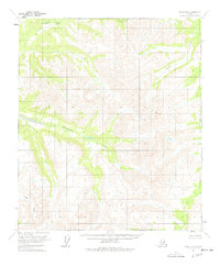
1956 Map of Eagle B-6
USGS Topo · Published 1965About this map
The Goodpaster River basin in the Fairbanks Meridian area is defined by a network of drainage systems that carve through the high elevations of the Alaska interior. This mid-century topographical record shows the Eisenmenger Fork feeding into the main river system, a critical waterway for early exploration and seasonal movement through this unpopulated terrain. The map reflects a landscape in 1956 where land lines remained unsurveyed and unmarked, as predetermined by the Bureau of Land Management. The intricate contour lines illustrate the steep relief surrounding Joseph Creek and the southern Boulder Creek, detailing a wilderness that, at the time of these 1954 aerial photographs, was largely untouched by permanent roads or infrastructure.
Find a feature on this map
4 named features on this map. Tap any name to fly to it.
Don’t see what you’re looking for? This feature index may not catch every label — zoom into the map to look around manually.
Map Details
Editions of this 1956 Eagle B-6 Map
2 editions found
Other maps of this area

1950 · Big Delta
USGS Topo · 1:250,000

1951 · Big Delta
USGS Topo · 1:250,000

1951 · Eagle
USGS Topo · 1:250,000

1955 · Big Delta A-1
USGS Topo · 1:63,360

1956 · Eagle A-5
USGS Topo · 1:63,360

1956 · Eagle B-5
USGS Topo · 1:63,360

1956 · Eagle C-6
USGS Topo · 1:63,360

1956 · Eagle A-6
USGS Topo · 1:63,360

1956 · Eagle C-5
USGS Topo · 1:63,360

1957 · Eagle
USGS Topo · 1:250,000