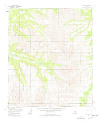
1956 Map of Eagle B-6
USGS Topo · Published 1978About this map
The Goodpaster River winds through the northern reaches of this interior Alaskan landscape, marking a territory of complex hydrology and significant relief. Mapped in the mid-1950s using photogrammetric methods, the area is defined by the convergence of several major drainage systems, including the Eisenmenger Fork and Joseph Creek. The absence of established roads or permanent settlements in this quadrangle reflects the isolated character of the Fairbanks Meridian at this time, where land lines remained largely unsurveyed and unmarked by the Bureau of Land Management. Researchers interested in the natural topography of the region can trace the descent of Boulder Creek through the southwest, seeing how the water networks dictated the shape of the land before any modern infrastructure altered the drainage patterns.
Find a feature on this map
4 named features on this map. Tap any name to fly to it.
Don’t see what you’re looking for? This feature index may not catch every label — zoom into the map to look around manually.
Map Details
Editions of this 1956 Eagle B-6 Map
2 editions found
Other maps of this area

1950 · Big Delta
USGS Topo · 1:250,000

1951 · Big Delta
USGS Topo · 1:250,000

1951 · Eagle
USGS Topo · 1:250,000

1955 · Big Delta A-1
USGS Topo · 1:63,360

1956 · Eagle A-5
USGS Topo · 1:63,360

1956 · Eagle B-5
USGS Topo · 1:63,360

1956 · Eagle C-6
USGS Topo · 1:63,360

1956 · Eagle A-6
USGS Topo · 1:63,360

1956 · Eagle B-6
USGS Topo · 1:63,360

1956 · Eagle C-5
USGS Topo · 1:63,360