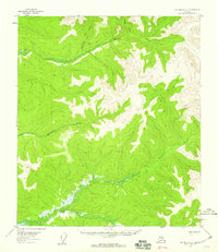
1955 Map of Big Delta A-1
USGS Topo · Published 1959About this map
The South Fork Goodpaster River and its major tributaries dominate this mid-century topographic study of the Alaska interior. Relying on aerial photography from 1954 and field annotation from 1955, the map documents a largely unsettled wilderness where hydrology is the primary geographic marker. The complex drainage systems of the Volkmar River and Healy River are captured in fine detail, illustrating the rhythmic interplay of ridges and valleys that define the subarctic landscape. Smaller waterways like Divide Creek and Serpentine Creek feed into these larger river systems, which serve as the historical corridors for movement through this part of the Southeast Fairbanks region. Without roads or permanent settlements recorded, the map emphasizes the raw physical geography of the territory before significant infrastructure development.
Find a feature on this map
5 named features on this map. Tap any name to fly to it.
Don’t see what you’re looking for? This feature index may not catch every label — zoom into the map to look around manually.
Map Details
Editions of this 1955 Big Delta A-1 Map
3 editions found
Historical Maps of Unorganized Borough Through Time
634 maps found

1899 Fortymile
Southeast Fairbanks Borough, AK

1948 Tanacross A-3
Southeast Fairbanks Borough, AK

1948 Tanacross A-4
Southeast Fairbanks Borough, AK

1948 Tanacross A-5
Southeast Fairbanks Borough, AK

1948 Tanacross A-6
Southeast Fairbanks Borough, AK

1948 Tanacross B-3
Southeast Fairbanks Borough, AK

1948 Tanacross B-5
Southeast Fairbanks Borough, AK

1949 Big Delta A-6
Southeast Fairbanks Borough, AK

1949 Tanacross A-5
Southeast Fairbanks Borough, AK

1949 Tanacross B-3
Southeast Fairbanks Borough, AK

1949 Tanacross B-4
Southeast Fairbanks Borough, AK

1949 Tanacross B-6
Southeast Fairbanks Borough, AK

1950 Big Delta A-4
Southeast Fairbanks Borough, AK

1950 Big Delta A-5
Southeast Fairbanks Borough, AK

1950 Big Delta B-4
Southeast Fairbanks Borough, AK

1950 Mount Hayes D-5
Southeast Fairbanks Borough, AK

1950 Mount Hayes D-6
Southeast Fairbanks Borough, AK

1950 Mount Hayes
Southeast Fairbanks Borough, AK

1950 Mt. Hayes C-4
Southeast Fairbanks Borough, AK

1950 Mt. Hayes D-1
Southeast Fairbanks Borough, AK

1951 Big Delta A-6
Southeast Fairbanks Borough, AK

1951 Mount Hayes C-5
Southeast Fairbanks Borough, AK

1951 Mount Hayes C-6
Southeast Fairbanks Borough, AK

1951 Mount Hayes
Southeast Fairbanks Borough, AK

1951 Tanacross B-4
Southeast Fairbanks Borough, AK

1951 Tanacross B-6
Southeast Fairbanks Borough, AK

1952 Big Delta A-4
Southeast Fairbanks Borough, AK

1952 Big Delta A-5
Southeast Fairbanks Borough, AK

1952 Mt. Hayes C-4
Southeast Fairbanks Borough, AK

1952 Mt. Hayes D-4
Southeast Fairbanks Borough, AK

1952 Mt. Hayes D-5
Southeast Fairbanks Borough, AK

1952 Mt. Hayes D-6
Southeast Fairbanks Borough, AK

1952 Nabesna D-1
Southeast Fairbanks Borough, AK

1952 Tanacross A-1
Southeast Fairbanks Borough, AK

1952 Tanacross A-3
Southeast Fairbanks Borough, AK

1952 Tanacross A-4
Southeast Fairbanks Borough, AK

1952 Tanacross A-5
Southeast Fairbanks Borough, AK

1952 Tanacross A-6
Southeast Fairbanks Borough, AK

1952 Tanacross B-3
Southeast Fairbanks Borough, AK

1952 Tanacross B-5
Southeast Fairbanks Borough, AK

1953 Big Delta B-4
Southeast Fairbanks Borough, AK

1954 Big Delta A-2
Southeast Fairbanks Borough, AK

1954 Mount Hayes C-1
Southeast Fairbanks Borough, AK

1954 Mount Hayes C-3
Southeast Fairbanks Borough, AK

1954 Mount Hayes D-2
Southeast Fairbanks Borough, AK

1954 Mount Hayes D-3
Southeast Fairbanks Borough, AK

1954 Mt. Hayes D-1
Southeast Fairbanks Borough, AK

1954 Nabesna C-3
Southeast Fairbanks Borough, AK

1954 Nabesna D-2
Southeast Fairbanks Borough, AK

1954 Nabesna D-3
Southeast Fairbanks Borough, AK

1954 Nabesna D-4
Southeast Fairbanks Borough, AK

1954 Tanacross A-2
Southeast Fairbanks Borough, AK

1954 Tanacross C-6
Southeast Fairbanks Borough, AK

1954 Tanacross D-6
Southeast Fairbanks Borough, AK

1955 Big Delta A-1
Southeast Fairbanks Borough, AK

1955 Big Delta A-2
Southeast Fairbanks Borough, AK

1955 Big Delta A-3
Southeast Fairbanks Borough, AK

1955 Mount Hayes C-1
Southeast Fairbanks Borough, AK

1955 Mount Hayes C-2
Southeast Fairbanks Borough, AK

1955 Mount Hayes C-3
Southeast Fairbanks Borough, AK

1955 Mount Hayes D-2
Southeast Fairbanks Borough, AK

1955 Mount Hayes
Southeast Fairbanks Borough, AK

1955 Mt. Hayes D-3
Southeast Fairbanks Borough, AK

1955 Nabesna C-1
Southeast Fairbanks Borough, AK

1955 Nabesna C-2
Southeast Fairbanks Borough, AK

1955 Nabesna C-3
Southeast Fairbanks Borough, AK

1955 Nabesna D-2
Southeast Fairbanks Borough, AK

1955 Nabesna D-3
Southeast Fairbanks Borough, AK

1955 Tanacross A-2
Southeast Fairbanks Borough, AK

1955 Tanacross C-6
Southeast Fairbanks Borough, AK

1955 Tanacross D-6
Southeast Fairbanks Borough, AK

1956 Charley River A-1
Southeast Fairbanks Borough, AK

1956 Charley River A-2
Southeast Fairbanks Borough, AK

1956 Charley River A-3
Southeast Fairbanks Borough, AK

1956 Charley River A-4
Southeast Fairbanks Borough, AK

1956 Charley River B-1
Southeast Fairbanks Borough, AK

1956 Charley River B-2
Southeast Fairbanks Borough, AK

1956 Charley River B-3
Southeast Fairbanks Borough, AK

1956 Charley River C-1
Southeast Fairbanks Borough, AK

1956 Eagle A-1
Southeast Fairbanks Borough, AK

1956 Eagle A-2
Southeast Fairbanks Borough, AK

1956 Eagle A-4
Southeast Fairbanks Borough, AK

1956 Eagle A-5
Southeast Fairbanks Borough, AK

1956 Eagle A-6
Southeast Fairbanks Borough, AK

1956 Eagle B-1
Southeast Fairbanks Borough, AK

1956 Eagle B-2
Southeast Fairbanks Borough, AK

1956 Eagle B-3
Southeast Fairbanks Borough, AK

1956 Eagle B-4
Southeast Fairbanks Borough, AK

1956 Eagle B-5
Southeast Fairbanks Borough, AK

1956 Eagle B-6
Southeast Fairbanks Borough, AK

1956 Eagle C-1
Southeast Fairbanks Borough, AK

1956 Eagle C-2
Southeast Fairbanks Borough, AK

1956 Eagle C-3
Southeast Fairbanks Borough, AK

1956 Eagle C-4
Southeast Fairbanks Borough, AK

1956 Eagle C-5
Southeast Fairbanks Borough, AK

1956 Eagle C-6
Southeast Fairbanks Borough, AK

1956 Eagle D-1
Southeast Fairbanks Borough, AK

1956 Eagle D-2
Southeast Fairbanks Borough, AK

1956 Eagle D-3
Southeast Fairbanks Borough, AK

1956 Eagle D-4
Southeast Fairbanks Borough, AK

1956 Eagle D-5
Southeast Fairbanks Borough, AK

1956 Tanacross B-1
Southeast Fairbanks Borough, AK

1956 Tanacross B-2
Southeast Fairbanks Borough, AK

1956 Tanacross C-1
Southeast Fairbanks Borough, AK

1956 Tanacross C-2
Southeast Fairbanks Borough, AK

1956 Tanacross C-3
Southeast Fairbanks Borough, AK

1956 Tanacross C-4
Southeast Fairbanks Borough, AK

1956 Tanacross C-5
Southeast Fairbanks Borough, AK

1956 Tanacross D-1
Southeast Fairbanks Borough, AK

1956 Tanacross D-2
Southeast Fairbanks Borough, AK

1956 Tanacross D-3
Southeast Fairbanks Borough, AK

1956 Tanacross D-4
Southeast Fairbanks Borough, AK

1956 Tanacross D-5
Southeast Fairbanks Borough, AK

1957 Eagle A-3
Southeast Fairbanks Borough, AK

1958 Big Delta B-1
Southeast Fairbanks Borough, AK

1958 Big Delta B-2
Southeast Fairbanks Borough, AK

1958 Big Delta B-3
Southeast Fairbanks Borough, AK

1958 Big Delta C-1
Southeast Fairbanks Borough, AK

1959 Big Delta A-4
Southeast Fairbanks Borough, AK

1959 Nabesna A-1
Southeast Fairbanks Borough, AK

1960 Nabesna A-2
Southeast Fairbanks Borough, AK

1960 Nabesna B-1
Southeast Fairbanks Borough, AK

1960 Nabesna B-2
Southeast Fairbanks Borough, AK

1960 Nabesna D-4
Southeast Fairbanks Borough, AK

1962 Big Delta A-4
Southeast Fairbanks Borough, AK

2013 Big Delta A-5 SE
Southeast Fairbanks Borough, AK

2013 Big Delta A-5 SW
Southeast Fairbanks Borough, AK

2013 Mount Hayes D-1 NE
Southeast Fairbanks Borough, AK

2013 Mount Hayes D-5 NE
Southeast Fairbanks Borough, AK

2013 Mount Hayes D-5 NW
Southeast Fairbanks Borough, AK

2013 Nabesna C-1 NE
Southeast Fairbanks Borough, AK

2013 Nabesna D-1 NE
Southeast Fairbanks Borough, AK

2013 Nabesna D-1 SE
Southeast Fairbanks Borough, AK

2013 Tanacross A-1 NE
Southeast Fairbanks Borough, AK

2013 Tanacross A-1 NW
Southeast Fairbanks Borough, AK

2013 Tanacross A-1 SE
Southeast Fairbanks Borough, AK

2013 Tanacross A-1 SW
Southeast Fairbanks Borough, AK

2013 Tanacross A-2 NE
Southeast Fairbanks Borough, AK

2013 Tanacross A-2 NW
Southeast Fairbanks Borough, AK

2013 Tanacross A-2 SE
Southeast Fairbanks Borough, AK

2013 Tanacross A-2 SW
Southeast Fairbanks Borough, AK

2013 Tanacross A-3 NE
Southeast Fairbanks Borough, AK

2013 Tanacross A-3 SE
Southeast Fairbanks Borough, AK

2013 Tanacross B-2 NW
Southeast Fairbanks Borough, AK

2013 Tanacross B-2 SW
Southeast Fairbanks Borough, AK

2013 Tanacross B-3 NE
Southeast Fairbanks Borough, AK

2013 Tanacross B-3 SE
Southeast Fairbanks Borough, AK

2013 Tanacross C-2 NE
Southeast Fairbanks Borough, AK

2013 Tanacross C-2 NW
Southeast Fairbanks Borough, AK

2013 Tanacross C-2 SE
Southeast Fairbanks Borough, AK

2013 Tanacross C-2 SW
Southeast Fairbanks Borough, AK

2013 Tanacross C-3 NE
Southeast Fairbanks Borough, AK

2013 Tanacross C-3 NW
Southeast Fairbanks Borough, AK

2013 Tanacross C-3 SE
Southeast Fairbanks Borough, AK

2013 Tanacross C-3 SW
Southeast Fairbanks Borough, AK

2013 Tanacross C-4 NE
Southeast Fairbanks Borough, AK

2013 Tanacross C-4 NW
Southeast Fairbanks Borough, AK

2013 Tanacross C-4 SE
Southeast Fairbanks Borough, AK

2013 Tanacross C-4 SW
Southeast Fairbanks Borough, AK

2013 Tanacross C-5 NE
Southeast Fairbanks Borough, AK

2013 Tanacross C-5 SE
Southeast Fairbanks Borough, AK

2013 Tanacross D-1 NE
Southeast Fairbanks Borough, AK

2013 Tanacross D-1 NW
Southeast Fairbanks Borough, AK

2013 Tanacross D-2 NE
Southeast Fairbanks Borough, AK

2013 Tanacross D-2 NW
Southeast Fairbanks Borough, AK

2013 Tanacross D-2 SE
Southeast Fairbanks Borough, AK

2013 Tanacross D-2 SW
Southeast Fairbanks Borough, AK

2013 Tanacross D-3 NE
Southeast Fairbanks Borough, AK

2013 Tanacross D-3 NW
Southeast Fairbanks Borough, AK

2013 Tanacross D-3 SE
Southeast Fairbanks Borough, AK

2013 Tanacross D-3 SW
Southeast Fairbanks Borough, AK

2013 Tanacross D-4 NE
Southeast Fairbanks Borough, AK

2013 Tanacross D-4 NW
Southeast Fairbanks Borough, AK

2013 Tanacross D-4 SE
Southeast Fairbanks Borough, AK

2013 Tanacross D-4 SW
Southeast Fairbanks Borough, AK

2013 Tanacross D-5 NE
Southeast Fairbanks Borough, AK

2013 Tanacross D-5 NW
Southeast Fairbanks Borough, AK

2013 Tanacross D-5 SE
Southeast Fairbanks Borough, AK

2013 Tanacross D-6 NE
Southeast Fairbanks Borough, AK

2013 Tanacross D-6 NW
Southeast Fairbanks Borough, AK

2015 Tanacross B-1 NE
Southeast Fairbanks Borough, AK

2015 Tanacross B-1 NW
Southeast Fairbanks Borough, AK

2015 Tanacross B-1 SE
Southeast Fairbanks Borough, AK

2015 Tanacross B-1 SW
Southeast Fairbanks Borough, AK

2015 Tanacross B-2 NE
Southeast Fairbanks Borough, AK

2015 Tanacross B-2 SE
Southeast Fairbanks Borough, AK

2015 Tanacross C-1 NE
Southeast Fairbanks Borough, AK

2015 Tanacross C-1 NW
Southeast Fairbanks Borough, AK

2015 Tanacross C-1 SE
Southeast Fairbanks Borough, AK

2015 Tanacross C-1 SW
Southeast Fairbanks Borough, AK

2015 Tanacross D-1 SE
Southeast Fairbanks Borough, AK

2015 Tanacross D-1 SW
Southeast Fairbanks Borough, AK

2016 Big Delta A-3 NE
Southeast Fairbanks Borough, AK

2016 Big Delta A-3 NW
Southeast Fairbanks Borough, AK

2016 Big Delta A-3 SE
Southeast Fairbanks Borough, AK

2016 Big Delta A-3 SW
Southeast Fairbanks Borough, AK

2016 Big Delta A-4 NE
Southeast Fairbanks Borough, AK

2016 Big Delta A-4 NW
Southeast Fairbanks Borough, AK

2016 Big Delta A-4 SE
Southeast Fairbanks Borough, AK

2016 Big Delta A-4 SW
Southeast Fairbanks Borough, AK

2016 Big Delta A-5 NE
Southeast Fairbanks Borough, AK

2016 Big Delta A-5 NW
Southeast Fairbanks Borough, AK

2016 Big Delta A-6 NE
Southeast Fairbanks Borough, AK

2016 Big Delta A-6 NW
Southeast Fairbanks Borough, AK

2016 Big Delta A-6 SE
Southeast Fairbanks Borough, AK

2016 Big Delta A-6 SW
Southeast Fairbanks Borough, AK

2016 Big Delta B-3 NE
Southeast Fairbanks Borough, AK

2016 Big Delta B-3 NW
Southeast Fairbanks Borough, AK

2016 Big Delta B-3 SE
Southeast Fairbanks Borough, AK

2016 Big Delta B-3 SW
Southeast Fairbanks Borough, AK

2016 Big Delta B-4 NE
Southeast Fairbanks Borough, AK

2016 Big Delta B-4 NW
Southeast Fairbanks Borough, AK

2016 Big Delta B-4 SE
Southeast Fairbanks Borough, AK

2016 Big Delta B-4 SW
Southeast Fairbanks Borough, AK

2016 Big Delta B-5 SE
Southeast Fairbanks Borough, AK

2016 Mount Hayes C-1 NE
Southeast Fairbanks Borough, AK

2016 Mount Hayes C-1 NW
Southeast Fairbanks Borough, AK

2016 Mount Hayes C-1 SE
Southeast Fairbanks Borough, AK

2016 Mount Hayes C-1 SW
Southeast Fairbanks Borough, AK

2016 Mount Hayes C-2 NE
Southeast Fairbanks Borough, AK

2016 Mount Hayes C-2 NW
Southeast Fairbanks Borough, AK

2016 Mount Hayes C-2 SE
Southeast Fairbanks Borough, AK

2016 Mount Hayes C-2 SW
Southeast Fairbanks Borough, AK

2016 Mount Hayes C-3 NE
Southeast Fairbanks Borough, AK

2016 Mount Hayes C-3 NW
Southeast Fairbanks Borough, AK

2016 Mount Hayes C-3 SE
Southeast Fairbanks Borough, AK

2016 Mount Hayes C-3 SW
Southeast Fairbanks Borough, AK

2016 Mount Hayes C-4 NE
Southeast Fairbanks Borough, AK

2016 Mount Hayes C-4 NW
Southeast Fairbanks Borough, AK

2016 Mount Hayes C-4 SE
Southeast Fairbanks Borough, AK

2016 Mount Hayes C-4 SW
Southeast Fairbanks Borough, AK

2016 Mount Hayes C-5 NE
Southeast Fairbanks Borough, AK

2016 Mount Hayes C-5 NW
Southeast Fairbanks Borough, AK

2016 Mount Hayes C-5 SE
Southeast Fairbanks Borough, AK

2016 Mount Hayes C-5 SW
Southeast Fairbanks Borough, AK

2016 Mount Hayes C-6 NE
Southeast Fairbanks Borough, AK

2016 Mount Hayes C-6 NW
Southeast Fairbanks Borough, AK

2016 Mount Hayes D-1 NW
Southeast Fairbanks Borough, AK

2016 Mount Hayes D-1 SE
Southeast Fairbanks Borough, AK

2016 Mount Hayes D-1 SW
Southeast Fairbanks Borough, AK

2016 Mount Hayes D-2 NE
Southeast Fairbanks Borough, AK

2016 Mount Hayes D-2 NW
Southeast Fairbanks Borough, AK

2016 Mount Hayes D-2 SE
Southeast Fairbanks Borough, AK

2016 Mount Hayes D-2 SW
Southeast Fairbanks Borough, AK

2016 Mount Hayes D-3 NE
Southeast Fairbanks Borough, AK

2016 Mount Hayes D-3 NW
Southeast Fairbanks Borough, AK

2016 Mount Hayes D-3 SE
Southeast Fairbanks Borough, AK

2016 Mount Hayes D-3 SW
Southeast Fairbanks Borough, AK

2016 Mount Hayes D-4 NE
Southeast Fairbanks Borough, AK

2016 Mount Hayes D-4 NW
Southeast Fairbanks Borough, AK

2016 Mount Hayes D-4 SE
Southeast Fairbanks Borough, AK

2016 Mount Hayes D-4 SW
Southeast Fairbanks Borough, AK

2016 Mount Hayes D-5 SE
Southeast Fairbanks Borough, AK

2016 Mount Hayes D-5 SW
Southeast Fairbanks Borough, AK

2016 Mount Hayes D-6 NE
Southeast Fairbanks Borough, AK

2016 Mount Hayes D-6 NW
Southeast Fairbanks Borough, AK

2016 Mount Hayes D-6 SE
Southeast Fairbanks Borough, AK

2016 Mount Hayes D-6 SW
Southeast Fairbanks Borough, AK

2016 Nabesna A-1 NE
Southeast Fairbanks Borough, AK

2016 Nabesna A-1 NW
Southeast Fairbanks Borough, AK

2016 Nabesna A-1 SE
Southeast Fairbanks Borough, AK

2016 Nabesna A-1 SW
Southeast Fairbanks Borough, AK

2016 Nabesna A-2 NE
Southeast Fairbanks Borough, AK

2016 Nabesna A-2 NW
Southeast Fairbanks Borough, AK

2016 Nabesna A-2 SE
Southeast Fairbanks Borough, AK

2016 Nabesna B-1 NE
Southeast Fairbanks Borough, AK

2016 Nabesna B-1 NW
Southeast Fairbanks Borough, AK

2016 Nabesna B-1 SE
Southeast Fairbanks Borough, AK

2016 Nabesna B-1 SW
Southeast Fairbanks Borough, AK

2016 Nabesna B-2 NE
Southeast Fairbanks Borough, AK

2016 Nabesna B-2 NW
Southeast Fairbanks Borough, AK

2016 Nabesna B-2 SE
Southeast Fairbanks Borough, AK

2016 Nabesna B-2 SW
Southeast Fairbanks Borough, AK

2016 Nabesna C-1 NW
Southeast Fairbanks Borough, AK

2016 Nabesna C-1 SE
Southeast Fairbanks Borough, AK

2016 Nabesna C-1 SW
Southeast Fairbanks Borough, AK

2016 Nabesna C-2 NE
Southeast Fairbanks Borough, AK

2016 Nabesna C-2 NW
Southeast Fairbanks Borough, AK

2016 Nabesna C-2 SE
Southeast Fairbanks Borough, AK

2016 Nabesna C-2 SW
Southeast Fairbanks Borough, AK

2016 Nabesna C-3 NE
Southeast Fairbanks Borough, AK

2016 Nabesna C-3 NW
Southeast Fairbanks Borough, AK

2016 Nabesna C-3 SE
Southeast Fairbanks Borough, AK

2016 Nabesna C-4 NW
Southeast Fairbanks Borough, AK

2016 Nabesna D-1 SW
Southeast Fairbanks Borough, AK

2016 Nabesna D-2 NW
Southeast Fairbanks Borough, AK

2016 Nabesna D-2 SE
Southeast Fairbanks Borough, AK

2016 Nabesna D-2 SW
Southeast Fairbanks Borough, AK

2016 Nabesna D-3 NE
Southeast Fairbanks Borough, AK

2016 Nabesna D-3 NW
Southeast Fairbanks Borough, AK

2016 Nabesna D-3 SE
Southeast Fairbanks Borough, AK

2016 Nabesna D-3 SW
Southeast Fairbanks Borough, AK

2016 Nabesna D-4 NE
Southeast Fairbanks Borough, AK

2016 Nabesna D-4 NW
Southeast Fairbanks Borough, AK

2016 Nabesna D-4 SE
Southeast Fairbanks Borough, AK

2016 Nabesna D-4 SW
Southeast Fairbanks Borough, AK

2016 Tanacross A-3 NW
Southeast Fairbanks Borough, AK

2016 Tanacross A-3 SW
Southeast Fairbanks Borough, AK

2016 Tanacross A-4 NE
Southeast Fairbanks Borough, AK

2016 Tanacross A-4 NW
Southeast Fairbanks Borough, AK

2016 Tanacross A-4 SE
Southeast Fairbanks Borough, AK

2016 Tanacross A-4 SW
Southeast Fairbanks Borough, AK

2016 Tanacross A-5 NE
Southeast Fairbanks Borough, AK

2016 Tanacross A-5 NW
Southeast Fairbanks Borough, AK

2016 Tanacross A-6 NE
Southeast Fairbanks Borough, AK

2016 Tanacross A-6 NW
Southeast Fairbanks Borough, AK

2016 Tanacross B-3 NW
Southeast Fairbanks Borough, AK

2016 Tanacross B-3 SW
Southeast Fairbanks Borough, AK

2016 Tanacross B-4 NE
Southeast Fairbanks Borough, AK

2016 Tanacross B-4 NW
Southeast Fairbanks Borough, AK

2016 Tanacross B-4 SE
Southeast Fairbanks Borough, AK

2016 Tanacross B-4 SW
Southeast Fairbanks Borough, AK

2016 Tanacross B-5 NE
Southeast Fairbanks Borough, AK

2016 Tanacross B-5 NW
Southeast Fairbanks Borough, AK

2016 Tanacross B-5 SE
Southeast Fairbanks Borough, AK

2016 Tanacross B-5 SW
Southeast Fairbanks Borough, AK

2016 Tanacross B-6 NE
Southeast Fairbanks Borough, AK

2016 Tanacross B-6 NW
Southeast Fairbanks Borough, AK

2016 Tanacross B-6 SE
Southeast Fairbanks Borough, AK

2016 Tanacross B-6 SW
Southeast Fairbanks Borough, AK

2016 Tanacross C-5 NW
Southeast Fairbanks Borough, AK

2016 Tanacross C-5 SW
Southeast Fairbanks Borough, AK

2016 Tanacross C-6 NE
Southeast Fairbanks Borough, AK

2016 Tanacross C-6 NW
Southeast Fairbanks Borough, AK

2016 Tanacross C-6 SE
Southeast Fairbanks Borough, AK

2016 Tanacross C-6 SW
Southeast Fairbanks Borough, AK

2016 Tanacross D-5 SW
Southeast Fairbanks Borough, AK

2016 Tanacross D-6 SE
Southeast Fairbanks Borough, AK

2016 Tanacross D-6 SW
Southeast Fairbanks Borough, AK

2017 Nabesna D-1 NW
Southeast Fairbanks Borough, AK

2017 Nabesna D-2 NE
Southeast Fairbanks Borough, AK

2018 Big Delta A-1 NE
Southeast Fairbanks Borough, AK

2018 Big Delta A-1 NW
Southeast Fairbanks Borough, AK

2018 Big Delta A-1 SE
Southeast Fairbanks Borough, AK

2018 Big Delta A-1 SW
Southeast Fairbanks Borough, AK

2018 Big Delta A-2 NE
Southeast Fairbanks Borough, AK

2018 Big Delta A-2 NW
Southeast Fairbanks Borough, AK

2018 Big Delta A-2 SE
Southeast Fairbanks Borough, AK

2018 Big Delta A-2 SW
Southeast Fairbanks Borough, AK

2018 Big Delta B-1 NE
Southeast Fairbanks Borough, AK

2018 Big Delta B-1 NW
Southeast Fairbanks Borough, AK

2018 Big Delta B-1 SE
Southeast Fairbanks Borough, AK

2018 Big Delta B-1 SW
Southeast Fairbanks Borough, AK

2018 Big Delta B-2 NE
Southeast Fairbanks Borough, AK

2018 Big Delta B-2 NW
Southeast Fairbanks Borough, AK

2018 Big Delta B-2 SE
Southeast Fairbanks Borough, AK

2018 Big Delta B-2 SW
Southeast Fairbanks Borough, AK

2018 Big Delta C-1 SE
Southeast Fairbanks Borough, AK

2018 Big Delta C-1 SW
Southeast Fairbanks Borough, AK

2018 Big Delta C-2 SE
Southeast Fairbanks Borough, AK

2018 Big Delta C-2 SW
Southeast Fairbanks Borough, AK

2018 Charley River A-1 NE
Southeast Fairbanks Borough, AK

2018 Charley River A-1 NW
Southeast Fairbanks Borough, AK

2018 Charley River A-1 SE
Southeast Fairbanks Borough, AK

2018 Charley River A-1 SW
Southeast Fairbanks Borough, AK

2018 Charley River A-2 NE
Southeast Fairbanks Borough, AK

2018 Charley River A-2 NW
Southeast Fairbanks Borough, AK

2018 Charley River A-2 SE
Southeast Fairbanks Borough, AK

2018 Charley River A-2 SW
Southeast Fairbanks Borough, AK

2018 Charley River A-3 NE
Southeast Fairbanks Borough, AK

2018 Charley River A-3 NW
Southeast Fairbanks Borough, AK

2018 Charley River A-3 SE
Southeast Fairbanks Borough, AK

2018 Charley River A-3 SW
Southeast Fairbanks Borough, AK

2018 Charley River A-4 NE
Southeast Fairbanks Borough, AK

2018 Charley River A-4 SE
Southeast Fairbanks Borough, AK

2018 Charley River A-4 SW
Southeast Fairbanks Borough, AK

2018 Charley River A-5 SE
Southeast Fairbanks Borough, AK

2018 Charley River B-1 NE
Southeast Fairbanks Borough, AK

2018 Charley River B-1 NW
Southeast Fairbanks Borough, AK

2018 Charley River B-1 SE
Southeast Fairbanks Borough, AK

2018 Charley River B-1 SW
Southeast Fairbanks Borough, AK

2018 Charley River B-2 NE
Southeast Fairbanks Borough, AK

2018 Charley River B-2 NW
Southeast Fairbanks Borough, AK

2018 Charley River B-2 SE
Southeast Fairbanks Borough, AK

2018 Charley River B-2 SW
Southeast Fairbanks Borough, AK

2018 Charley River B-3 NE
Southeast Fairbanks Borough, AK

2018 Charley River B-3 SE
Southeast Fairbanks Borough, AK

2018 Charley River B-3 SW
Southeast Fairbanks Borough, AK

2018 Charley River B-4 SE
Southeast Fairbanks Borough, AK

2018 Charley River C-1 NE
Southeast Fairbanks Borough, AK

2018 Charley River C-1 SE
Southeast Fairbanks Borough, AK

2018 Charley River C-1 SW
Southeast Fairbanks Borough, AK

2018 Charley River D-1 SE
Southeast Fairbanks Borough, AK

2018 Eagle A-1 NE
Southeast Fairbanks Borough, AK

2018 Eagle A-1 NW
Southeast Fairbanks Borough, AK

2018 Eagle A-1 SE
Southeast Fairbanks Borough, AK

2018 Eagle A-1 SW
Southeast Fairbanks Borough, AK

2018 Eagle A-2 NE
Southeast Fairbanks Borough, AK

2018 Eagle A-2 NW
Southeast Fairbanks Borough, AK

2018 Eagle A-2 SE
Southeast Fairbanks Borough, AK

2018 Eagle A-2 SW
Southeast Fairbanks Borough, AK

2018 Eagle A-3 NE
Southeast Fairbanks Borough, AK

2018 Eagle A-3 NW
Southeast Fairbanks Borough, AK

2018 Eagle A-3 SE
Southeast Fairbanks Borough, AK

2018 Eagle A-3 SW
Southeast Fairbanks Borough, AK

2018 Eagle A-4 NE
Southeast Fairbanks Borough, AK

2018 Eagle A-4 NW
Southeast Fairbanks Borough, AK

2018 Eagle A-4 SE
Southeast Fairbanks Borough, AK

2018 Eagle A-4 SW
Southeast Fairbanks Borough, AK

2018 Eagle A-5 NE
Southeast Fairbanks Borough, AK

2018 Eagle A-5 NW
Southeast Fairbanks Borough, AK

2018 Eagle A-5 SE
Southeast Fairbanks Borough, AK

2018 Eagle A-5 SW
Southeast Fairbanks Borough, AK

2018 Eagle A-6 NE
Southeast Fairbanks Borough, AK

2018 Eagle A-6 NW
Southeast Fairbanks Borough, AK

2018 Eagle A-6 SE
Southeast Fairbanks Borough, AK

2018 Eagle A-6 SW
Southeast Fairbanks Borough, AK

2018 Eagle B-1 NE
Southeast Fairbanks Borough, AK

2018 Eagle B-1 NW
Southeast Fairbanks Borough, AK

2018 Eagle B-1 SE
Southeast Fairbanks Borough, AK

2018 Eagle B-1 SW
Southeast Fairbanks Borough, AK

2018 Eagle B-2 NE
Southeast Fairbanks Borough, AK

2018 Eagle B-2 NW
Southeast Fairbanks Borough, AK

2018 Eagle B-2 SE
Southeast Fairbanks Borough, AK

2018 Eagle B-2 SW
Southeast Fairbanks Borough, AK

2018 Eagle B-3 NE
Southeast Fairbanks Borough, AK

2018 Eagle B-3 NW
Southeast Fairbanks Borough, AK

2018 Eagle B-3 SE
Southeast Fairbanks Borough, AK

2018 Eagle B-3 SW
Southeast Fairbanks Borough, AK

2018 Eagle B-4 NE
Southeast Fairbanks Borough, AK

2018 Eagle B-4 NW
Southeast Fairbanks Borough, AK

2018 Eagle B-4 SE
Southeast Fairbanks Borough, AK

2018 Eagle B-4 SW
Southeast Fairbanks Borough, AK

2018 Eagle B-5 NE
Southeast Fairbanks Borough, AK

2018 Eagle B-5 NW
Southeast Fairbanks Borough, AK

2018 Eagle B-5 SE
Southeast Fairbanks Borough, AK

2018 Eagle B-5 SW
Southeast Fairbanks Borough, AK

2018 Eagle B-6 NE
Southeast Fairbanks Borough, AK

2018 Eagle B-6 NW
Southeast Fairbanks Borough, AK

2018 Eagle B-6 SE
Southeast Fairbanks Borough, AK

2018 Eagle B-6 SW
Southeast Fairbanks Borough, AK

2018 Eagle C-1 NE
Southeast Fairbanks Borough, AK

2018 Eagle C-1 NW
Southeast Fairbanks Borough, AK

2018 Eagle C-1 SE
Southeast Fairbanks Borough, AK

2018 Eagle C-1 SW
Southeast Fairbanks Borough, AK

2018 Eagle C-2 NE
Southeast Fairbanks Borough, AK

2018 Eagle C-2 NW
Southeast Fairbanks Borough, AK

2018 Eagle C-2 SE
Southeast Fairbanks Borough, AK

2018 Eagle C-2 SW
Southeast Fairbanks Borough, AK

2018 Eagle C-3 NE
Southeast Fairbanks Borough, AK

2018 Eagle C-3 NW
Southeast Fairbanks Borough, AK

2018 Eagle C-3 SE
Southeast Fairbanks Borough, AK

2018 Eagle C-3 SW
Southeast Fairbanks Borough, AK

2018 Eagle C-4 NE
Southeast Fairbanks Borough, AK

2018 Eagle C-4 NW
Southeast Fairbanks Borough, AK

2018 Eagle C-4 SE
Southeast Fairbanks Borough, AK

2018 Eagle C-4 SW
Southeast Fairbanks Borough, AK

2018 Eagle C-5 NE
Southeast Fairbanks Borough, AK

2018 Eagle C-5 NW
Southeast Fairbanks Borough, AK

2018 Eagle C-5 SE
Southeast Fairbanks Borough, AK

2018 Eagle C-5 SW
Southeast Fairbanks Borough, AK

2018 Eagle C-6 NE
Southeast Fairbanks Borough, AK

2018 Eagle C-6 SE
Southeast Fairbanks Borough, AK

2018 Eagle C-6 SW
Southeast Fairbanks Borough, AK

2018 Eagle D-1 NE
Southeast Fairbanks Borough, AK

2018 Eagle D-1 NW
Southeast Fairbanks Borough, AK

2018 Eagle D-1 SE
Southeast Fairbanks Borough, AK

2018 Eagle D-1 SW
Southeast Fairbanks Borough, AK

2018 Eagle D-2 NE
Southeast Fairbanks Borough, AK

2018 Eagle D-2 NW
Southeast Fairbanks Borough, AK

2018 Eagle D-2 SE
Southeast Fairbanks Borough, AK

2018 Eagle D-2 SW
Southeast Fairbanks Borough, AK

2018 Eagle D-3 NE
Southeast Fairbanks Borough, AK

2018 Eagle D-3 NW
Southeast Fairbanks Borough, AK

2018 Eagle D-3 SE
Southeast Fairbanks Borough, AK

2018 Eagle D-3 SW
Southeast Fairbanks Borough, AK

2018 Eagle D-4 NE
Southeast Fairbanks Borough, AK

2018 Eagle D-4 NW
Southeast Fairbanks Borough, AK

2018 Eagle D-4 SE
Southeast Fairbanks Borough, AK

2018 Eagle D-4 SW
Southeast Fairbanks Borough, AK

2018 Eagle D-5 NE
Southeast Fairbanks Borough, AK

2018 Eagle D-5 NW
Southeast Fairbanks Borough, AK

2018 Eagle D-5 SE
Southeast Fairbanks Borough, AK

2018 Eagle D-5 SW
Southeast Fairbanks Borough, AK

2023 Charley River A-1 SE
Southeast Fairbanks Borough, AK

2023 Eagle A-1 NE
Southeast Fairbanks Borough, AK

2023 Eagle A-1 NW
Southeast Fairbanks Borough, AK

2023 Nabesna A-1 NE
Southeast Fairbanks Borough, AK

2023 Nabesna A-1 NW
Southeast Fairbanks Borough, AK

2023 Nabesna A-1 SE
Southeast Fairbanks Borough, AK

2023 Nabesna A-1 SW
Southeast Fairbanks Borough, AK

2023 Nabesna A-2 NE
Southeast Fairbanks Borough, AK

2023 Nabesna A-2 NW
Southeast Fairbanks Borough, AK

2023 Nabesna A-2 SE
Southeast Fairbanks Borough, AK

2023 Nabesna B-1 NE
Southeast Fairbanks Borough, AK

2023 Nabesna B-1 NW
Southeast Fairbanks Borough, AK

2023 Nabesna B-1 SE
Southeast Fairbanks Borough, AK

2023 Nabesna B-1 SW
Southeast Fairbanks Borough, AK

2023 Nabesna B-2 NE
Southeast Fairbanks Borough, AK

2023 Nabesna B-2 NW
Southeast Fairbanks Borough, AK

2023 Nabesna B-2 SE
Southeast Fairbanks Borough, AK

2023 Nabesna B-2 SW
Southeast Fairbanks Borough, AK

2023 Nabesna C-1 NE
Southeast Fairbanks Borough, AK

2023 Nabesna C-1 NW
Southeast Fairbanks Borough, AK

2023 Nabesna C-1 SE
Southeast Fairbanks Borough, AK

2023 Nabesna C-1 SW
Southeast Fairbanks Borough, AK

2023 Nabesna C-2 NE
Southeast Fairbanks Borough, AK

2023 Nabesna C-2 NW
Southeast Fairbanks Borough, AK

2023 Nabesna C-2 SE
Southeast Fairbanks Borough, AK

2023 Nabesna C-2 SW
Southeast Fairbanks Borough, AK

2023 Nabesna C-3 NE
Southeast Fairbanks Borough, AK

2023 Nabesna C-3 NW
Southeast Fairbanks Borough, AK

2023 Nabesna C-3 SE
Southeast Fairbanks Borough, AK

2023 Nabesna C-4 NW
Southeast Fairbanks Borough, AK

2023 Nabesna D-1 NW
Southeast Fairbanks Borough, AK

2023 Nabesna D-1 SE
Southeast Fairbanks Borough, AK

2023 Nabesna D-1 SW
Southeast Fairbanks Borough, AK

2023 Nabesna D-2 NE
Southeast Fairbanks Borough, AK

2023 Nabesna D-2 NW
Southeast Fairbanks Borough, AK

2023 Nabesna D-2 SE
Southeast Fairbanks Borough, AK

2023 Nabesna D-2 SW
Southeast Fairbanks Borough, AK

2023 Nabesna D-3 NE
Southeast Fairbanks Borough, AK

2023 Nabesna D-3 NW
Southeast Fairbanks Borough, AK

2023 Nabesna D-3 SE
Southeast Fairbanks Borough, AK

2023 Nabesna D-3 SW
Southeast Fairbanks Borough, AK

2023 Nabesna D-4 NE
Southeast Fairbanks Borough, AK

2023 Nabesna D-4 NW
Southeast Fairbanks Borough, AK

2023 Nabesna D-4 SE
Southeast Fairbanks Borough, AK

2023 Nabesna D-4 SW
Southeast Fairbanks Borough, AK

2024 Big Delta A-1 NE
Southeast Fairbanks Borough, AK

2024 Big Delta A-1 NW
Southeast Fairbanks Borough, AK

2024 Big Delta A-1 SE
Southeast Fairbanks Borough, AK

2024 Big Delta A-1 SW
Southeast Fairbanks Borough, AK

2024 Big Delta A-2 NE
Southeast Fairbanks Borough, AK

2024 Big Delta A-2 NW
Southeast Fairbanks Borough, AK

2024 Big Delta A-2 SE
Southeast Fairbanks Borough, AK

2024 Big Delta A-2 SW
Southeast Fairbanks Borough, AK

2024 Big Delta A-3 NE
Southeast Fairbanks Borough, AK

2024 Big Delta A-3 NW
Southeast Fairbanks Borough, AK

2024 Big Delta A-3 SE
Southeast Fairbanks Borough, AK

2024 Big Delta A-3 SW
Southeast Fairbanks Borough, AK

2024 Big Delta A-4 NE
Southeast Fairbanks Borough, AK

2024 Big Delta A-4 SE
Southeast Fairbanks Borough, AK

2024 Big Delta B-1 NE
Southeast Fairbanks Borough, AK

2024 Big Delta B-1 NW
Southeast Fairbanks Borough, AK

2024 Big Delta B-1 SE
Southeast Fairbanks Borough, AK

2024 Big Delta B-1 SW
Southeast Fairbanks Borough, AK

2024 Big Delta B-2 NE
Southeast Fairbanks Borough, AK

2024 Big Delta B-2 NW
Southeast Fairbanks Borough, AK

2024 Big Delta B-2 SE
Southeast Fairbanks Borough, AK

2024 Big Delta B-2 SW
Southeast Fairbanks Borough, AK

2024 Big Delta B-3 NE
Southeast Fairbanks Borough, AK

2024 Big Delta B-3 NW
Southeast Fairbanks Borough, AK

2024 Big Delta B-3 SE
Southeast Fairbanks Borough, AK

2024 Big Delta B-3 SW
Southeast Fairbanks Borough, AK

2024 Big Delta B-4 NE
Southeast Fairbanks Borough, AK

2024 Big Delta B-4 NW
Southeast Fairbanks Borough, AK

2024 Big Delta B-4 SE
Southeast Fairbanks Borough, AK

2024 Big Delta B-5 SE
Southeast Fairbanks Borough, AK

2024 Big Delta C-1 SE
Southeast Fairbanks Borough, AK

2024 Big Delta C-1 SW
Southeast Fairbanks Borough, AK

2024 Big Delta C-2 SE
Southeast Fairbanks Borough, AK

2024 Big Delta C-2 SW
Southeast Fairbanks Borough, AK

2024 Eagle A-6 NE
Southeast Fairbanks Borough, AK

2024 Eagle A-6 NW
Southeast Fairbanks Borough, AK

2024 Eagle A-6 SW
Southeast Fairbanks Borough, AK

2024 Eagle B-6 NE
Southeast Fairbanks Borough, AK

2024 Eagle B-6 NW
Southeast Fairbanks Borough, AK

2024 Eagle B-6 SE
Southeast Fairbanks Borough, AK

2024 Eagle B-6 SW
Southeast Fairbanks Borough, AK

2024 Eagle C-6 SE
Southeast Fairbanks Borough, AK

2024 Eagle C-6 SW
Southeast Fairbanks Borough, AK

2024 Mount Hayes C-1 NE
Southeast Fairbanks Borough, AK

2024 Mount Hayes C-1 NW
Southeast Fairbanks Borough, AK

2024 Mount Hayes C-1 SE
Southeast Fairbanks Borough, AK

2024 Mount Hayes C-1 SW
Southeast Fairbanks Borough, AK

2024 Mount Hayes C-2 NE
Southeast Fairbanks Borough, AK

2024 Mount Hayes C-2 NW
Southeast Fairbanks Borough, AK

2024 Mount Hayes C-2 SE
Southeast Fairbanks Borough, AK

2024 Mount Hayes C-2 SW
Southeast Fairbanks Borough, AK

2024 Mount Hayes C-3 NE
Southeast Fairbanks Borough, AK

2024 Mount Hayes C-3 NW
Southeast Fairbanks Borough, AK

2024 Mount Hayes C-3 SE
Southeast Fairbanks Borough, AK

2024 Mount Hayes C-3 SW
Southeast Fairbanks Borough, AK

2024 Mount Hayes C-4 NE
Southeast Fairbanks Borough, AK

2024 Mount Hayes D-1 NE
Southeast Fairbanks Borough, AK

2024 Mount Hayes D-1 NW
Southeast Fairbanks Borough, AK

2024 Mount Hayes D-1 SE
Southeast Fairbanks Borough, AK

2024 Mount Hayes D-1 SW
Southeast Fairbanks Borough, AK

2024 Mount Hayes D-2 NE
Southeast Fairbanks Borough, AK

2024 Mount Hayes D-2 NW
Southeast Fairbanks Borough, AK

2024 Mount Hayes D-2 SE
Southeast Fairbanks Borough, AK

2024 Mount Hayes D-2 SW
Southeast Fairbanks Borough, AK

2024 Mount Hayes D-3 NE
Southeast Fairbanks Borough, AK

2024 Mount Hayes D-3 NW
Southeast Fairbanks Borough, AK

2024 Mount Hayes D-3 SE
Southeast Fairbanks Borough, AK

2024 Mount Hayes D-3 SW
Southeast Fairbanks Borough, AK

2024 Mount Hayes D-4 NE
Southeast Fairbanks Borough, AK

2024 Mount Hayes D-4 SE
Southeast Fairbanks Borough, AK

2024 Nabesna D-1 NE
Southeast Fairbanks Borough, AK

2024 Tanacross A-1 NW
Southeast Fairbanks Borough, AK

2024 Tanacross A-1 SE
Southeast Fairbanks Borough, AK

2024 Tanacross A-1 SW
Southeast Fairbanks Borough, AK

2024 Tanacross A-2 NE
Southeast Fairbanks Borough, AK

2024 Tanacross A-2 NW
Southeast Fairbanks Borough, AK

2024 Tanacross A-2 SE
Southeast Fairbanks Borough, AK

2024 Tanacross A-2 SW
Southeast Fairbanks Borough, AK

2024 Tanacross A-3 NE
Southeast Fairbanks Borough, AK

2024 Tanacross A-3 NW
Southeast Fairbanks Borough, AK

2024 Tanacross A-3 SE
Southeast Fairbanks Borough, AK

2024 Tanacross A-3 SW
Southeast Fairbanks Borough, AK

2024 Tanacross A-4 NE
Southeast Fairbanks Borough, AK

2024 Tanacross A-4 NW
Southeast Fairbanks Borough, AK

2024 Tanacross A-4 SE
Southeast Fairbanks Borough, AK

2024 Tanacross A-4 SW
Southeast Fairbanks Borough, AK

2024 Tanacross A-5 NE
Southeast Fairbanks Borough, AK

2024 Tanacross A-5 NW
Southeast Fairbanks Borough, AK

2024 Tanacross A-6 NE
Southeast Fairbanks Borough, AK

2024 Tanacross A-6 NW
Southeast Fairbanks Borough, AK

2024 Tanacross B-3 SW
Southeast Fairbanks Borough, AK

2024 Tanacross B-4 NE
Southeast Fairbanks Borough, AK

2024 Tanacross B-4 NW
Southeast Fairbanks Borough, AK

2024 Tanacross B-4 SE
Southeast Fairbanks Borough, AK

2024 Tanacross B-4 SW
Southeast Fairbanks Borough, AK

2024 Tanacross B-5 NE
Southeast Fairbanks Borough, AK

2024 Tanacross B-5 NW
Southeast Fairbanks Borough, AK

2024 Tanacross B-5 SE
Southeast Fairbanks Borough, AK

2024 Tanacross B-5 SW
Southeast Fairbanks Borough, AK

2024 Tanacross B-6 NE
Southeast Fairbanks Borough, AK

2024 Tanacross B-6 NW
Southeast Fairbanks Borough, AK

2024 Tanacross B-6 SE
Southeast Fairbanks Borough, AK

2024 Tanacross B-6 SW
Southeast Fairbanks Borough, AK

2024 Tanacross C-5 NW
Southeast Fairbanks Borough, AK

2024 Tanacross C-5 SE
Southeast Fairbanks Borough, AK

2024 Tanacross C-5 SW
Southeast Fairbanks Borough, AK

2024 Tanacross C-6 NE
Southeast Fairbanks Borough, AK

2024 Tanacross C-6 NW
Southeast Fairbanks Borough, AK

2024 Tanacross C-6 SE
Southeast Fairbanks Borough, AK

2024 Tanacross C-6 SW
Southeast Fairbanks Borough, AK

2024 Tanacross D-5 SW
Southeast Fairbanks Borough, AK

2024 Tanacross D-6 NE
Southeast Fairbanks Borough, AK

2024 Tanacross D-6 NW
Southeast Fairbanks Borough, AK

2024 Tanacross D-6 SE
Southeast Fairbanks Borough, AK

2024 Tanacross D-6 SW
Southeast Fairbanks Borough, AK