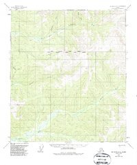
1955 Map of Big Delta A-1
USGS Topo · Published 1987About this map
The South Fork Goodpaster River and its numerous tributaries dominate this interior Alaskan landscape, which remains largely untouched by permanent settlement in the mid-1950s. The region is defined by a significant navigational and legal junction: the intersection of the North Boundary Seward Meridian and the South Boundary Copper River Meridian. This survey, based on 1954 aerial photography, documents the vital seasonal routes required for traversing this remote terrain, most notably the Winter Trail that cuts across the northern drainages near Serpentine Creek. To the south, the headwaters of the Volkmar River and Healy River suggest a complex watershed where water travel and winter sledding were the primary means of movement. The map serves as a primary record of the topographic divide near Divide Creek, illustrating how the land was surveyed and partitioned before significant modern development.
Find a feature on this map
9 named features on this map. Tap any name to fly to it.
Don’t see what you’re looking for? This feature index may not catch every label — zoom into the map to look around manually.
Map Details
Editions of this 1955 Big Delta A-1 Map
3 editions found

Other maps of this area

1949 · Tanacross
USGS Topo · 1:250,000

1950 · Tanacross
USGS Topo · 1:250,000

1950 · Mount Hayes
USGS Topo · 1:250,000

1950 · Big Delta
USGS Topo · 1:250,000

1951 · Big Delta
USGS Topo · 1:250,000

1951 · Mount Hayes
USGS Topo · 1:250,000

1951 · Eagle
USGS Topo · 1:250,000

1954 · Mount Hayes D-2
USGS Topo · 1:63,360

1954 · Mount Hayes D-1
USGS Topo · 1:63,360

1954 · Tanacross D-6
USGS Topo · 1:63,360