
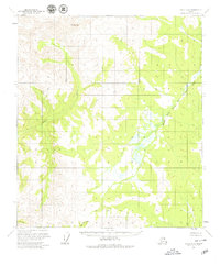
1956 Map of Eagle A-6
USGS Topo · Published 1965About this map
Mt Harper anchors the northwestern high ground of this interior Alaskan landscape, surveyed in the mid-1950s using photogrammetric methods from aerial photography. The terrain is defined by the drainage patterns of several significant waterways, most notably the Healy River and the North Fork Fortymile River. These rivers create deep valleys through the high country, with the North Fork flowing through a complex system of wetlands and small ponds in the eastern part of the quadrangle. The map reflects a wild and undeveloped region during the territorial period just prior to statehood, where Sand Creek and other tributaries carve through thousands of feet of elevation. Because the land lines shown were predetermined by the Bureau of Land Management but not yet surveyed or marked on the ground, the map captures a raw geographic state before formal land division or road construction reached this part of the interior.
Find a feature on this map
4 named features on this map. Tap any name to fly to it.
Don’t see what you’re looking for? This feature index may not catch every label — zoom into the map to look around manually.
Map Details
Editions of this 1956 Eagle A-6 Map
2 editions found
Other maps of this area

1949 · Tanacross
USGS Topo · 1:250,000

1950 · Tanacross
USGS Topo · 1:250,000

1950 · Mount Hayes
USGS Topo · 1:250,000

1950 · Big Delta
USGS Topo · 1:250,000

1951 · Big Delta
USGS Topo · 1:250,000

1951 · Mount Hayes
USGS Topo · 1:250,000

1951 · Eagle
USGS Topo · 1:250,000

1954 · Mount Hayes D-1
USGS Topo · 1:63,360

1954 · Tanacross D-6
USGS Topo · 1:63,360

1955 · Big Delta A-1
USGS Topo · 1:63,360