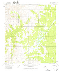
1956 Map of Eagle A-6
USGS Topo · Published 1979About this map
Mt Harper dominates the northwestern corner of this 1950s landscape, serving as a prominent landmark in a region defined by its complex drainage systems. The map illustrates a wilderness characterized by the winding courses of the Middle Fork Fortymile River and the Healy River, which carve through the terrain before the later era of more intensive resource mapping. Surveyed primarily through aerial photography from 1954 and 1957, these land lines represent unsurveyed and unmarked locations predetermined by the Bureau of Land Management. The absence of roads or established settlements at this time highlights the remote nature of the territory south of Sand Creek, where the river-and-creek network provided the primary means of orientation for early explorers and surveyors in the Alaska interior.
Find a feature on this map
4 named features on this map. Tap any name to fly to it.
Don’t see what you’re looking for? This feature index may not catch every label — zoom into the map to look around manually.
Map Details
Editions of this 1956 Eagle A-6 Map
2 editions found

Other maps of this area

1949 · Tanacross
USGS Topo · 1:250,000

1950 · Tanacross
USGS Topo · 1:250,000

1950 · Mount Hayes
USGS Topo · 1:250,000

1950 · Big Delta
USGS Topo · 1:250,000

1951 · Big Delta
USGS Topo · 1:250,000

1951 · Mount Hayes
USGS Topo · 1:250,000

1951 · Eagle
USGS Topo · 1:250,000

1954 · Mount Hayes D-1
USGS Topo · 1:63,360

1954 · Tanacross D-6
USGS Topo · 1:63,360

1955 · Big Delta A-1
USGS Topo · 1:63,360