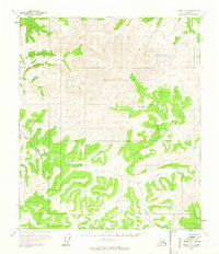
1956 Map of Eagle C-5
USGS Topo · Published 1966About this map
High-altitude interior terrain dominates this mid-century survey of the Alaska frontier. The landscape is defined by the sharp drainage of Ruby Creek in the southeastern quadrant and the prominent elevation of Copper toward the north. Mapping efforts by the U.S. Geological Survey during this era relied on aerial photography from 1954 and 1955 to chart this unsurveyed territory. The lack of established roads or settlements on this sheet reflects the wilderness character of the region before significant modern development, showing instead the natural contours and watercourses as they were first recorded for the Bureau of Land Management.
Find a feature on this map
2 named features on this map. Tap any name to fly to it.
Don’t see what you’re looking for? This feature index may not catch every label — zoom into the map to look around manually.
Map Details
Editions of this 1956 Eagle C-5 Map
2 editions found
Historical Maps of Unorganized Borough Through Time
634 maps found

1899 Fortymile
Southeast Fairbanks Borough, AK

1948 Tanacross A-3
Southeast Fairbanks Borough, AK

1948 Tanacross A-4
Southeast Fairbanks Borough, AK

1948 Tanacross A-5
Southeast Fairbanks Borough, AK

1948 Tanacross A-6
Southeast Fairbanks Borough, AK

1948 Tanacross B-3
Southeast Fairbanks Borough, AK

1948 Tanacross B-5
Southeast Fairbanks Borough, AK

1949 Big Delta A-6
Southeast Fairbanks Borough, AK

1949 Tanacross A-5
Southeast Fairbanks Borough, AK

1949 Tanacross B-3
Southeast Fairbanks Borough, AK

1949 Tanacross B-4
Southeast Fairbanks Borough, AK

1949 Tanacross B-6
Southeast Fairbanks Borough, AK

1950 Big Delta A-4
Southeast Fairbanks Borough, AK

1950 Big Delta A-5
Southeast Fairbanks Borough, AK

1950 Big Delta B-4
Southeast Fairbanks Borough, AK

1950 Mount Hayes D-5
Southeast Fairbanks Borough, AK

1950 Mount Hayes D-6
Southeast Fairbanks Borough, AK

1950 Mount Hayes
Southeast Fairbanks Borough, AK

1950 Mt. Hayes C-4
Southeast Fairbanks Borough, AK

1950 Mt. Hayes D-1
Southeast Fairbanks Borough, AK

1951 Big Delta A-6
Southeast Fairbanks Borough, AK

1951 Mount Hayes C-5
Southeast Fairbanks Borough, AK

1951 Mount Hayes C-6
Southeast Fairbanks Borough, AK

1951 Mount Hayes
Southeast Fairbanks Borough, AK

1951 Tanacross B-4
Southeast Fairbanks Borough, AK

1951 Tanacross B-6
Southeast Fairbanks Borough, AK

1952 Big Delta A-4
Southeast Fairbanks Borough, AK

1952 Big Delta A-5
Southeast Fairbanks Borough, AK

1952 Mt. Hayes C-4
Southeast Fairbanks Borough, AK

1952 Mt. Hayes D-4
Southeast Fairbanks Borough, AK

1952 Mt. Hayes D-5
Southeast Fairbanks Borough, AK

1952 Mt. Hayes D-6
Southeast Fairbanks Borough, AK

1952 Nabesna D-1
Southeast Fairbanks Borough, AK

1952 Tanacross A-1
Southeast Fairbanks Borough, AK

1952 Tanacross A-3
Southeast Fairbanks Borough, AK

1952 Tanacross A-4
Southeast Fairbanks Borough, AK

1952 Tanacross A-5
Southeast Fairbanks Borough, AK

1952 Tanacross A-6
Southeast Fairbanks Borough, AK

1952 Tanacross B-3
Southeast Fairbanks Borough, AK

1952 Tanacross B-5
Southeast Fairbanks Borough, AK

1953 Big Delta B-4
Southeast Fairbanks Borough, AK

1954 Big Delta A-2
Southeast Fairbanks Borough, AK

1954 Mount Hayes C-1
Southeast Fairbanks Borough, AK

1954 Mount Hayes C-3
Southeast Fairbanks Borough, AK

1954 Mount Hayes D-2
Southeast Fairbanks Borough, AK

1954 Mount Hayes D-3
Southeast Fairbanks Borough, AK

1954 Mt. Hayes D-1
Southeast Fairbanks Borough, AK

1954 Nabesna C-3
Southeast Fairbanks Borough, AK

1954 Nabesna D-2
Southeast Fairbanks Borough, AK

1954 Nabesna D-3
Southeast Fairbanks Borough, AK

1954 Nabesna D-4
Southeast Fairbanks Borough, AK

1954 Tanacross A-2
Southeast Fairbanks Borough, AK

1954 Tanacross C-6
Southeast Fairbanks Borough, AK

1954 Tanacross D-6
Southeast Fairbanks Borough, AK

1955 Big Delta A-1
Southeast Fairbanks Borough, AK

1955 Big Delta A-2
Southeast Fairbanks Borough, AK

1955 Big Delta A-3
Southeast Fairbanks Borough, AK

1955 Mount Hayes C-1
Southeast Fairbanks Borough, AK

1955 Mount Hayes C-2
Southeast Fairbanks Borough, AK

1955 Mount Hayes C-3
Southeast Fairbanks Borough, AK

1955 Mount Hayes D-2
Southeast Fairbanks Borough, AK

1955 Mount Hayes
Southeast Fairbanks Borough, AK

1955 Mt. Hayes D-3
Southeast Fairbanks Borough, AK

1955 Nabesna C-1
Southeast Fairbanks Borough, AK

1955 Nabesna C-2
Southeast Fairbanks Borough, AK

1955 Nabesna C-3
Southeast Fairbanks Borough, AK

1955 Nabesna D-2
Southeast Fairbanks Borough, AK

1955 Nabesna D-3
Southeast Fairbanks Borough, AK

1955 Tanacross A-2
Southeast Fairbanks Borough, AK

1955 Tanacross C-6
Southeast Fairbanks Borough, AK

1955 Tanacross D-6
Southeast Fairbanks Borough, AK

1956 Charley River A-1
Southeast Fairbanks Borough, AK

1956 Charley River A-2
Southeast Fairbanks Borough, AK

1956 Charley River A-3
Southeast Fairbanks Borough, AK

1956 Charley River A-4
Southeast Fairbanks Borough, AK

1956 Charley River B-1
Southeast Fairbanks Borough, AK

1956 Charley River B-2
Southeast Fairbanks Borough, AK

1956 Charley River B-3
Southeast Fairbanks Borough, AK

1956 Charley River C-1
Southeast Fairbanks Borough, AK

1956 Eagle A-1
Southeast Fairbanks Borough, AK

1956 Eagle A-2
Southeast Fairbanks Borough, AK

1956 Eagle A-4
Southeast Fairbanks Borough, AK

1956 Eagle A-5
Southeast Fairbanks Borough, AK

1956 Eagle A-6
Southeast Fairbanks Borough, AK

1956 Eagle B-1
Southeast Fairbanks Borough, AK

1956 Eagle B-2
Southeast Fairbanks Borough, AK

1956 Eagle B-3
Southeast Fairbanks Borough, AK

1956 Eagle B-4
Southeast Fairbanks Borough, AK

1956 Eagle B-5
Southeast Fairbanks Borough, AK

1956 Eagle B-6
Southeast Fairbanks Borough, AK

1956 Eagle C-1
Southeast Fairbanks Borough, AK

1956 Eagle C-2
Southeast Fairbanks Borough, AK

1956 Eagle C-3
Southeast Fairbanks Borough, AK

1956 Eagle C-4
Southeast Fairbanks Borough, AK

1956 Eagle C-5
Southeast Fairbanks Borough, AK

1956 Eagle C-6
Southeast Fairbanks Borough, AK

1956 Eagle D-1
Southeast Fairbanks Borough, AK

1956 Eagle D-2
Southeast Fairbanks Borough, AK

1956 Eagle D-3
Southeast Fairbanks Borough, AK

1956 Eagle D-4
Southeast Fairbanks Borough, AK

1956 Eagle D-5
Southeast Fairbanks Borough, AK

1956 Tanacross B-1
Southeast Fairbanks Borough, AK

1956 Tanacross B-2
Southeast Fairbanks Borough, AK

1956 Tanacross C-1
Southeast Fairbanks Borough, AK

1956 Tanacross C-2
Southeast Fairbanks Borough, AK

1956 Tanacross C-3
Southeast Fairbanks Borough, AK

1956 Tanacross C-4
Southeast Fairbanks Borough, AK

1956 Tanacross C-5
Southeast Fairbanks Borough, AK

1956 Tanacross D-1
Southeast Fairbanks Borough, AK

1956 Tanacross D-2
Southeast Fairbanks Borough, AK

1956 Tanacross D-3
Southeast Fairbanks Borough, AK

1956 Tanacross D-4
Southeast Fairbanks Borough, AK

1956 Tanacross D-5
Southeast Fairbanks Borough, AK

1957 Eagle A-3
Southeast Fairbanks Borough, AK

1958 Big Delta B-1
Southeast Fairbanks Borough, AK

1958 Big Delta B-2
Southeast Fairbanks Borough, AK

1958 Big Delta B-3
Southeast Fairbanks Borough, AK

1958 Big Delta C-1
Southeast Fairbanks Borough, AK

1959 Big Delta A-4
Southeast Fairbanks Borough, AK

1959 Nabesna A-1
Southeast Fairbanks Borough, AK

1960 Nabesna A-2
Southeast Fairbanks Borough, AK

1960 Nabesna B-1
Southeast Fairbanks Borough, AK

1960 Nabesna B-2
Southeast Fairbanks Borough, AK

1960 Nabesna D-4
Southeast Fairbanks Borough, AK

1962 Big Delta A-4
Southeast Fairbanks Borough, AK

2013 Big Delta A-5 SE
Southeast Fairbanks Borough, AK

2013 Big Delta A-5 SW
Southeast Fairbanks Borough, AK

2013 Mount Hayes D-1 NE
Southeast Fairbanks Borough, AK

2013 Mount Hayes D-5 NE
Southeast Fairbanks Borough, AK

2013 Mount Hayes D-5 NW
Southeast Fairbanks Borough, AK

2013 Nabesna C-1 NE
Southeast Fairbanks Borough, AK

2013 Nabesna D-1 NE
Southeast Fairbanks Borough, AK

2013 Nabesna D-1 SE
Southeast Fairbanks Borough, AK

2013 Tanacross A-1 NE
Southeast Fairbanks Borough, AK

2013 Tanacross A-1 NW
Southeast Fairbanks Borough, AK

2013 Tanacross A-1 SE
Southeast Fairbanks Borough, AK

2013 Tanacross A-1 SW
Southeast Fairbanks Borough, AK

2013 Tanacross A-2 NE
Southeast Fairbanks Borough, AK

2013 Tanacross A-2 NW
Southeast Fairbanks Borough, AK

2013 Tanacross A-2 SE
Southeast Fairbanks Borough, AK

2013 Tanacross A-2 SW
Southeast Fairbanks Borough, AK

2013 Tanacross A-3 NE
Southeast Fairbanks Borough, AK

2013 Tanacross A-3 SE
Southeast Fairbanks Borough, AK

2013 Tanacross B-2 NW
Southeast Fairbanks Borough, AK

2013 Tanacross B-2 SW
Southeast Fairbanks Borough, AK

2013 Tanacross B-3 NE
Southeast Fairbanks Borough, AK

2013 Tanacross B-3 SE
Southeast Fairbanks Borough, AK

2013 Tanacross C-2 NE
Southeast Fairbanks Borough, AK

2013 Tanacross C-2 NW
Southeast Fairbanks Borough, AK

2013 Tanacross C-2 SE
Southeast Fairbanks Borough, AK

2013 Tanacross C-2 SW
Southeast Fairbanks Borough, AK

2013 Tanacross C-3 NE
Southeast Fairbanks Borough, AK

2013 Tanacross C-3 NW
Southeast Fairbanks Borough, AK

2013 Tanacross C-3 SE
Southeast Fairbanks Borough, AK

2013 Tanacross C-3 SW
Southeast Fairbanks Borough, AK

2013 Tanacross C-4 NE
Southeast Fairbanks Borough, AK

2013 Tanacross C-4 NW
Southeast Fairbanks Borough, AK

2013 Tanacross C-4 SE
Southeast Fairbanks Borough, AK

2013 Tanacross C-4 SW
Southeast Fairbanks Borough, AK

2013 Tanacross C-5 NE
Southeast Fairbanks Borough, AK

2013 Tanacross C-5 SE
Southeast Fairbanks Borough, AK

2013 Tanacross D-1 NE
Southeast Fairbanks Borough, AK

2013 Tanacross D-1 NW
Southeast Fairbanks Borough, AK

2013 Tanacross D-2 NE
Southeast Fairbanks Borough, AK

2013 Tanacross D-2 NW
Southeast Fairbanks Borough, AK

2013 Tanacross D-2 SE
Southeast Fairbanks Borough, AK

2013 Tanacross D-2 SW
Southeast Fairbanks Borough, AK

2013 Tanacross D-3 NE
Southeast Fairbanks Borough, AK

2013 Tanacross D-3 NW
Southeast Fairbanks Borough, AK

2013 Tanacross D-3 SE
Southeast Fairbanks Borough, AK

2013 Tanacross D-3 SW
Southeast Fairbanks Borough, AK

2013 Tanacross D-4 NE
Southeast Fairbanks Borough, AK

2013 Tanacross D-4 NW
Southeast Fairbanks Borough, AK

2013 Tanacross D-4 SE
Southeast Fairbanks Borough, AK

2013 Tanacross D-4 SW
Southeast Fairbanks Borough, AK

2013 Tanacross D-5 NE
Southeast Fairbanks Borough, AK

2013 Tanacross D-5 NW
Southeast Fairbanks Borough, AK

2013 Tanacross D-5 SE
Southeast Fairbanks Borough, AK

2013 Tanacross D-6 NE
Southeast Fairbanks Borough, AK

2013 Tanacross D-6 NW
Southeast Fairbanks Borough, AK

2015 Tanacross B-1 NE
Southeast Fairbanks Borough, AK

2015 Tanacross B-1 NW
Southeast Fairbanks Borough, AK

2015 Tanacross B-1 SE
Southeast Fairbanks Borough, AK

2015 Tanacross B-1 SW
Southeast Fairbanks Borough, AK

2015 Tanacross B-2 NE
Southeast Fairbanks Borough, AK

2015 Tanacross B-2 SE
Southeast Fairbanks Borough, AK

2015 Tanacross C-1 NE
Southeast Fairbanks Borough, AK

2015 Tanacross C-1 NW
Southeast Fairbanks Borough, AK

2015 Tanacross C-1 SE
Southeast Fairbanks Borough, AK

2015 Tanacross C-1 SW
Southeast Fairbanks Borough, AK

2015 Tanacross D-1 SE
Southeast Fairbanks Borough, AK

2015 Tanacross D-1 SW
Southeast Fairbanks Borough, AK

2016 Big Delta A-3 NE
Southeast Fairbanks Borough, AK

2016 Big Delta A-3 NW
Southeast Fairbanks Borough, AK

2016 Big Delta A-3 SE
Southeast Fairbanks Borough, AK

2016 Big Delta A-3 SW
Southeast Fairbanks Borough, AK

2016 Big Delta A-4 NE
Southeast Fairbanks Borough, AK

2016 Big Delta A-4 NW
Southeast Fairbanks Borough, AK

2016 Big Delta A-4 SE
Southeast Fairbanks Borough, AK

2016 Big Delta A-4 SW
Southeast Fairbanks Borough, AK

2016 Big Delta A-5 NE
Southeast Fairbanks Borough, AK

2016 Big Delta A-5 NW
Southeast Fairbanks Borough, AK

2016 Big Delta A-6 NE
Southeast Fairbanks Borough, AK

2016 Big Delta A-6 NW
Southeast Fairbanks Borough, AK

2016 Big Delta A-6 SE
Southeast Fairbanks Borough, AK

2016 Big Delta A-6 SW
Southeast Fairbanks Borough, AK

2016 Big Delta B-3 NE
Southeast Fairbanks Borough, AK

2016 Big Delta B-3 NW
Southeast Fairbanks Borough, AK

2016 Big Delta B-3 SE
Southeast Fairbanks Borough, AK

2016 Big Delta B-3 SW
Southeast Fairbanks Borough, AK

2016 Big Delta B-4 NE
Southeast Fairbanks Borough, AK

2016 Big Delta B-4 NW
Southeast Fairbanks Borough, AK

2016 Big Delta B-4 SE
Southeast Fairbanks Borough, AK

2016 Big Delta B-4 SW
Southeast Fairbanks Borough, AK

2016 Big Delta B-5 SE
Southeast Fairbanks Borough, AK

2016 Mount Hayes C-1 NE
Southeast Fairbanks Borough, AK

2016 Mount Hayes C-1 NW
Southeast Fairbanks Borough, AK

2016 Mount Hayes C-1 SE
Southeast Fairbanks Borough, AK

2016 Mount Hayes C-1 SW
Southeast Fairbanks Borough, AK

2016 Mount Hayes C-2 NE
Southeast Fairbanks Borough, AK

2016 Mount Hayes C-2 NW
Southeast Fairbanks Borough, AK

2016 Mount Hayes C-2 SE
Southeast Fairbanks Borough, AK

2016 Mount Hayes C-2 SW
Southeast Fairbanks Borough, AK

2016 Mount Hayes C-3 NE
Southeast Fairbanks Borough, AK

2016 Mount Hayes C-3 NW
Southeast Fairbanks Borough, AK

2016 Mount Hayes C-3 SE
Southeast Fairbanks Borough, AK

2016 Mount Hayes C-3 SW
Southeast Fairbanks Borough, AK

2016 Mount Hayes C-4 NE
Southeast Fairbanks Borough, AK

2016 Mount Hayes C-4 NW
Southeast Fairbanks Borough, AK

2016 Mount Hayes C-4 SE
Southeast Fairbanks Borough, AK

2016 Mount Hayes C-4 SW
Southeast Fairbanks Borough, AK

2016 Mount Hayes C-5 NE
Southeast Fairbanks Borough, AK

2016 Mount Hayes C-5 NW
Southeast Fairbanks Borough, AK

2016 Mount Hayes C-5 SE
Southeast Fairbanks Borough, AK

2016 Mount Hayes C-5 SW
Southeast Fairbanks Borough, AK

2016 Mount Hayes C-6 NE
Southeast Fairbanks Borough, AK

2016 Mount Hayes C-6 NW
Southeast Fairbanks Borough, AK

2016 Mount Hayes D-1 NW
Southeast Fairbanks Borough, AK

2016 Mount Hayes D-1 SE
Southeast Fairbanks Borough, AK

2016 Mount Hayes D-1 SW
Southeast Fairbanks Borough, AK

2016 Mount Hayes D-2 NE
Southeast Fairbanks Borough, AK

2016 Mount Hayes D-2 NW
Southeast Fairbanks Borough, AK

2016 Mount Hayes D-2 SE
Southeast Fairbanks Borough, AK

2016 Mount Hayes D-2 SW
Southeast Fairbanks Borough, AK

2016 Mount Hayes D-3 NE
Southeast Fairbanks Borough, AK

2016 Mount Hayes D-3 NW
Southeast Fairbanks Borough, AK

2016 Mount Hayes D-3 SE
Southeast Fairbanks Borough, AK

2016 Mount Hayes D-3 SW
Southeast Fairbanks Borough, AK

2016 Mount Hayes D-4 NE
Southeast Fairbanks Borough, AK

2016 Mount Hayes D-4 NW
Southeast Fairbanks Borough, AK

2016 Mount Hayes D-4 SE
Southeast Fairbanks Borough, AK

2016 Mount Hayes D-4 SW
Southeast Fairbanks Borough, AK

2016 Mount Hayes D-5 SE
Southeast Fairbanks Borough, AK

2016 Mount Hayes D-5 SW
Southeast Fairbanks Borough, AK

2016 Mount Hayes D-6 NE
Southeast Fairbanks Borough, AK

2016 Mount Hayes D-6 NW
Southeast Fairbanks Borough, AK

2016 Mount Hayes D-6 SE
Southeast Fairbanks Borough, AK

2016 Mount Hayes D-6 SW
Southeast Fairbanks Borough, AK

2016 Nabesna A-1 NE
Southeast Fairbanks Borough, AK

2016 Nabesna A-1 NW
Southeast Fairbanks Borough, AK

2016 Nabesna A-1 SE
Southeast Fairbanks Borough, AK

2016 Nabesna A-1 SW
Southeast Fairbanks Borough, AK

2016 Nabesna A-2 NE
Southeast Fairbanks Borough, AK

2016 Nabesna A-2 NW
Southeast Fairbanks Borough, AK

2016 Nabesna A-2 SE
Southeast Fairbanks Borough, AK

2016 Nabesna B-1 NE
Southeast Fairbanks Borough, AK

2016 Nabesna B-1 NW
Southeast Fairbanks Borough, AK

2016 Nabesna B-1 SE
Southeast Fairbanks Borough, AK

2016 Nabesna B-1 SW
Southeast Fairbanks Borough, AK

2016 Nabesna B-2 NE
Southeast Fairbanks Borough, AK

2016 Nabesna B-2 NW
Southeast Fairbanks Borough, AK

2016 Nabesna B-2 SE
Southeast Fairbanks Borough, AK

2016 Nabesna B-2 SW
Southeast Fairbanks Borough, AK

2016 Nabesna C-1 NW
Southeast Fairbanks Borough, AK

2016 Nabesna C-1 SE
Southeast Fairbanks Borough, AK

2016 Nabesna C-1 SW
Southeast Fairbanks Borough, AK

2016 Nabesna C-2 NE
Southeast Fairbanks Borough, AK

2016 Nabesna C-2 NW
Southeast Fairbanks Borough, AK

2016 Nabesna C-2 SE
Southeast Fairbanks Borough, AK

2016 Nabesna C-2 SW
Southeast Fairbanks Borough, AK

2016 Nabesna C-3 NE
Southeast Fairbanks Borough, AK

2016 Nabesna C-3 NW
Southeast Fairbanks Borough, AK

2016 Nabesna C-3 SE
Southeast Fairbanks Borough, AK

2016 Nabesna C-4 NW
Southeast Fairbanks Borough, AK

2016 Nabesna D-1 SW
Southeast Fairbanks Borough, AK

2016 Nabesna D-2 NW
Southeast Fairbanks Borough, AK

2016 Nabesna D-2 SE
Southeast Fairbanks Borough, AK

2016 Nabesna D-2 SW
Southeast Fairbanks Borough, AK

2016 Nabesna D-3 NE
Southeast Fairbanks Borough, AK

2016 Nabesna D-3 NW
Southeast Fairbanks Borough, AK

2016 Nabesna D-3 SE
Southeast Fairbanks Borough, AK

2016 Nabesna D-3 SW
Southeast Fairbanks Borough, AK

2016 Nabesna D-4 NE
Southeast Fairbanks Borough, AK

2016 Nabesna D-4 NW
Southeast Fairbanks Borough, AK

2016 Nabesna D-4 SE
Southeast Fairbanks Borough, AK

2016 Nabesna D-4 SW
Southeast Fairbanks Borough, AK

2016 Tanacross A-3 NW
Southeast Fairbanks Borough, AK

2016 Tanacross A-3 SW
Southeast Fairbanks Borough, AK

2016 Tanacross A-4 NE
Southeast Fairbanks Borough, AK

2016 Tanacross A-4 NW
Southeast Fairbanks Borough, AK

2016 Tanacross A-4 SE
Southeast Fairbanks Borough, AK

2016 Tanacross A-4 SW
Southeast Fairbanks Borough, AK

2016 Tanacross A-5 NE
Southeast Fairbanks Borough, AK

2016 Tanacross A-5 NW
Southeast Fairbanks Borough, AK

2016 Tanacross A-6 NE
Southeast Fairbanks Borough, AK

2016 Tanacross A-6 NW
Southeast Fairbanks Borough, AK

2016 Tanacross B-3 NW
Southeast Fairbanks Borough, AK

2016 Tanacross B-3 SW
Southeast Fairbanks Borough, AK

2016 Tanacross B-4 NE
Southeast Fairbanks Borough, AK

2016 Tanacross B-4 NW
Southeast Fairbanks Borough, AK

2016 Tanacross B-4 SE
Southeast Fairbanks Borough, AK

2016 Tanacross B-4 SW
Southeast Fairbanks Borough, AK

2016 Tanacross B-5 NE
Southeast Fairbanks Borough, AK

2016 Tanacross B-5 NW
Southeast Fairbanks Borough, AK

2016 Tanacross B-5 SE
Southeast Fairbanks Borough, AK

2016 Tanacross B-5 SW
Southeast Fairbanks Borough, AK

2016 Tanacross B-6 NE
Southeast Fairbanks Borough, AK

2016 Tanacross B-6 NW
Southeast Fairbanks Borough, AK

2016 Tanacross B-6 SE
Southeast Fairbanks Borough, AK

2016 Tanacross B-6 SW
Southeast Fairbanks Borough, AK

2016 Tanacross C-5 NW
Southeast Fairbanks Borough, AK

2016 Tanacross C-5 SW
Southeast Fairbanks Borough, AK

2016 Tanacross C-6 NE
Southeast Fairbanks Borough, AK

2016 Tanacross C-6 NW
Southeast Fairbanks Borough, AK

2016 Tanacross C-6 SE
Southeast Fairbanks Borough, AK

2016 Tanacross C-6 SW
Southeast Fairbanks Borough, AK

2016 Tanacross D-5 SW
Southeast Fairbanks Borough, AK

2016 Tanacross D-6 SE
Southeast Fairbanks Borough, AK

2016 Tanacross D-6 SW
Southeast Fairbanks Borough, AK

2017 Nabesna D-1 NW
Southeast Fairbanks Borough, AK

2017 Nabesna D-2 NE
Southeast Fairbanks Borough, AK

2018 Big Delta A-1 NE
Southeast Fairbanks Borough, AK

2018 Big Delta A-1 NW
Southeast Fairbanks Borough, AK

2018 Big Delta A-1 SE
Southeast Fairbanks Borough, AK

2018 Big Delta A-1 SW
Southeast Fairbanks Borough, AK

2018 Big Delta A-2 NE
Southeast Fairbanks Borough, AK

2018 Big Delta A-2 NW
Southeast Fairbanks Borough, AK

2018 Big Delta A-2 SE
Southeast Fairbanks Borough, AK

2018 Big Delta A-2 SW
Southeast Fairbanks Borough, AK

2018 Big Delta B-1 NE
Southeast Fairbanks Borough, AK

2018 Big Delta B-1 NW
Southeast Fairbanks Borough, AK

2018 Big Delta B-1 SE
Southeast Fairbanks Borough, AK

2018 Big Delta B-1 SW
Southeast Fairbanks Borough, AK

2018 Big Delta B-2 NE
Southeast Fairbanks Borough, AK

2018 Big Delta B-2 NW
Southeast Fairbanks Borough, AK

2018 Big Delta B-2 SE
Southeast Fairbanks Borough, AK

2018 Big Delta B-2 SW
Southeast Fairbanks Borough, AK

2018 Big Delta C-1 SE
Southeast Fairbanks Borough, AK

2018 Big Delta C-1 SW
Southeast Fairbanks Borough, AK

2018 Big Delta C-2 SE
Southeast Fairbanks Borough, AK

2018 Big Delta C-2 SW
Southeast Fairbanks Borough, AK

2018 Charley River A-1 NE
Southeast Fairbanks Borough, AK

2018 Charley River A-1 NW
Southeast Fairbanks Borough, AK

2018 Charley River A-1 SE
Southeast Fairbanks Borough, AK

2018 Charley River A-1 SW
Southeast Fairbanks Borough, AK

2018 Charley River A-2 NE
Southeast Fairbanks Borough, AK

2018 Charley River A-2 NW
Southeast Fairbanks Borough, AK

2018 Charley River A-2 SE
Southeast Fairbanks Borough, AK

2018 Charley River A-2 SW
Southeast Fairbanks Borough, AK

2018 Charley River A-3 NE
Southeast Fairbanks Borough, AK

2018 Charley River A-3 NW
Southeast Fairbanks Borough, AK

2018 Charley River A-3 SE
Southeast Fairbanks Borough, AK

2018 Charley River A-3 SW
Southeast Fairbanks Borough, AK

2018 Charley River A-4 NE
Southeast Fairbanks Borough, AK

2018 Charley River A-4 SE
Southeast Fairbanks Borough, AK

2018 Charley River A-4 SW
Southeast Fairbanks Borough, AK

2018 Charley River A-5 SE
Southeast Fairbanks Borough, AK

2018 Charley River B-1 NE
Southeast Fairbanks Borough, AK

2018 Charley River B-1 NW
Southeast Fairbanks Borough, AK

2018 Charley River B-1 SE
Southeast Fairbanks Borough, AK

2018 Charley River B-1 SW
Southeast Fairbanks Borough, AK

2018 Charley River B-2 NE
Southeast Fairbanks Borough, AK

2018 Charley River B-2 NW
Southeast Fairbanks Borough, AK

2018 Charley River B-2 SE
Southeast Fairbanks Borough, AK

2018 Charley River B-2 SW
Southeast Fairbanks Borough, AK

2018 Charley River B-3 NE
Southeast Fairbanks Borough, AK

2018 Charley River B-3 SE
Southeast Fairbanks Borough, AK

2018 Charley River B-3 SW
Southeast Fairbanks Borough, AK

2018 Charley River B-4 SE
Southeast Fairbanks Borough, AK

2018 Charley River C-1 NE
Southeast Fairbanks Borough, AK

2018 Charley River C-1 SE
Southeast Fairbanks Borough, AK

2018 Charley River C-1 SW
Southeast Fairbanks Borough, AK

2018 Charley River D-1 SE
Southeast Fairbanks Borough, AK

2018 Eagle A-1 NE
Southeast Fairbanks Borough, AK

2018 Eagle A-1 NW
Southeast Fairbanks Borough, AK

2018 Eagle A-1 SE
Southeast Fairbanks Borough, AK

2018 Eagle A-1 SW
Southeast Fairbanks Borough, AK

2018 Eagle A-2 NE
Southeast Fairbanks Borough, AK

2018 Eagle A-2 NW
Southeast Fairbanks Borough, AK

2018 Eagle A-2 SE
Southeast Fairbanks Borough, AK

2018 Eagle A-2 SW
Southeast Fairbanks Borough, AK

2018 Eagle A-3 NE
Southeast Fairbanks Borough, AK

2018 Eagle A-3 NW
Southeast Fairbanks Borough, AK

2018 Eagle A-3 SE
Southeast Fairbanks Borough, AK

2018 Eagle A-3 SW
Southeast Fairbanks Borough, AK

2018 Eagle A-4 NE
Southeast Fairbanks Borough, AK

2018 Eagle A-4 NW
Southeast Fairbanks Borough, AK

2018 Eagle A-4 SE
Southeast Fairbanks Borough, AK

2018 Eagle A-4 SW
Southeast Fairbanks Borough, AK

2018 Eagle A-5 NE
Southeast Fairbanks Borough, AK

2018 Eagle A-5 NW
Southeast Fairbanks Borough, AK

2018 Eagle A-5 SE
Southeast Fairbanks Borough, AK

2018 Eagle A-5 SW
Southeast Fairbanks Borough, AK

2018 Eagle A-6 NE
Southeast Fairbanks Borough, AK

2018 Eagle A-6 NW
Southeast Fairbanks Borough, AK

2018 Eagle A-6 SE
Southeast Fairbanks Borough, AK

2018 Eagle A-6 SW
Southeast Fairbanks Borough, AK

2018 Eagle B-1 NE
Southeast Fairbanks Borough, AK

2018 Eagle B-1 NW
Southeast Fairbanks Borough, AK

2018 Eagle B-1 SE
Southeast Fairbanks Borough, AK

2018 Eagle B-1 SW
Southeast Fairbanks Borough, AK

2018 Eagle B-2 NE
Southeast Fairbanks Borough, AK

2018 Eagle B-2 NW
Southeast Fairbanks Borough, AK

2018 Eagle B-2 SE
Southeast Fairbanks Borough, AK

2018 Eagle B-2 SW
Southeast Fairbanks Borough, AK

2018 Eagle B-3 NE
Southeast Fairbanks Borough, AK

2018 Eagle B-3 NW
Southeast Fairbanks Borough, AK

2018 Eagle B-3 SE
Southeast Fairbanks Borough, AK

2018 Eagle B-3 SW
Southeast Fairbanks Borough, AK

2018 Eagle B-4 NE
Southeast Fairbanks Borough, AK

2018 Eagle B-4 NW
Southeast Fairbanks Borough, AK

2018 Eagle B-4 SE
Southeast Fairbanks Borough, AK

2018 Eagle B-4 SW
Southeast Fairbanks Borough, AK

2018 Eagle B-5 NE
Southeast Fairbanks Borough, AK

2018 Eagle B-5 NW
Southeast Fairbanks Borough, AK

2018 Eagle B-5 SE
Southeast Fairbanks Borough, AK

2018 Eagle B-5 SW
Southeast Fairbanks Borough, AK

2018 Eagle B-6 NE
Southeast Fairbanks Borough, AK

2018 Eagle B-6 NW
Southeast Fairbanks Borough, AK

2018 Eagle B-6 SE
Southeast Fairbanks Borough, AK

2018 Eagle B-6 SW
Southeast Fairbanks Borough, AK

2018 Eagle C-1 NE
Southeast Fairbanks Borough, AK

2018 Eagle C-1 NW
Southeast Fairbanks Borough, AK

2018 Eagle C-1 SE
Southeast Fairbanks Borough, AK

2018 Eagle C-1 SW
Southeast Fairbanks Borough, AK

2018 Eagle C-2 NE
Southeast Fairbanks Borough, AK

2018 Eagle C-2 NW
Southeast Fairbanks Borough, AK

2018 Eagle C-2 SE
Southeast Fairbanks Borough, AK

2018 Eagle C-2 SW
Southeast Fairbanks Borough, AK

2018 Eagle C-3 NE
Southeast Fairbanks Borough, AK

2018 Eagle C-3 NW
Southeast Fairbanks Borough, AK

2018 Eagle C-3 SE
Southeast Fairbanks Borough, AK

2018 Eagle C-3 SW
Southeast Fairbanks Borough, AK

2018 Eagle C-4 NE
Southeast Fairbanks Borough, AK

2018 Eagle C-4 NW
Southeast Fairbanks Borough, AK

2018 Eagle C-4 SE
Southeast Fairbanks Borough, AK

2018 Eagle C-4 SW
Southeast Fairbanks Borough, AK

2018 Eagle C-5 NE
Southeast Fairbanks Borough, AK

2018 Eagle C-5 NW
Southeast Fairbanks Borough, AK

2018 Eagle C-5 SE
Southeast Fairbanks Borough, AK

2018 Eagle C-5 SW
Southeast Fairbanks Borough, AK

2018 Eagle C-6 NE
Southeast Fairbanks Borough, AK

2018 Eagle C-6 SE
Southeast Fairbanks Borough, AK

2018 Eagle C-6 SW
Southeast Fairbanks Borough, AK

2018 Eagle D-1 NE
Southeast Fairbanks Borough, AK

2018 Eagle D-1 NW
Southeast Fairbanks Borough, AK

2018 Eagle D-1 SE
Southeast Fairbanks Borough, AK

2018 Eagle D-1 SW
Southeast Fairbanks Borough, AK

2018 Eagle D-2 NE
Southeast Fairbanks Borough, AK

2018 Eagle D-2 NW
Southeast Fairbanks Borough, AK

2018 Eagle D-2 SE
Southeast Fairbanks Borough, AK

2018 Eagle D-2 SW
Southeast Fairbanks Borough, AK

2018 Eagle D-3 NE
Southeast Fairbanks Borough, AK

2018 Eagle D-3 NW
Southeast Fairbanks Borough, AK

2018 Eagle D-3 SE
Southeast Fairbanks Borough, AK

2018 Eagle D-3 SW
Southeast Fairbanks Borough, AK

2018 Eagle D-4 NE
Southeast Fairbanks Borough, AK

2018 Eagle D-4 NW
Southeast Fairbanks Borough, AK

2018 Eagle D-4 SE
Southeast Fairbanks Borough, AK

2018 Eagle D-4 SW
Southeast Fairbanks Borough, AK

2018 Eagle D-5 NE
Southeast Fairbanks Borough, AK

2018 Eagle D-5 NW
Southeast Fairbanks Borough, AK

2018 Eagle D-5 SE
Southeast Fairbanks Borough, AK

2018 Eagle D-5 SW
Southeast Fairbanks Borough, AK

2023 Charley River A-1 SE
Southeast Fairbanks Borough, AK

2023 Eagle A-1 NE
Southeast Fairbanks Borough, AK

2023 Eagle A-1 NW
Southeast Fairbanks Borough, AK

2023 Nabesna A-1 NE
Southeast Fairbanks Borough, AK

2023 Nabesna A-1 NW
Southeast Fairbanks Borough, AK

2023 Nabesna A-1 SE
Southeast Fairbanks Borough, AK

2023 Nabesna A-1 SW
Southeast Fairbanks Borough, AK

2023 Nabesna A-2 NE
Southeast Fairbanks Borough, AK

2023 Nabesna A-2 NW
Southeast Fairbanks Borough, AK

2023 Nabesna A-2 SE
Southeast Fairbanks Borough, AK

2023 Nabesna B-1 NE
Southeast Fairbanks Borough, AK

2023 Nabesna B-1 NW
Southeast Fairbanks Borough, AK

2023 Nabesna B-1 SE
Southeast Fairbanks Borough, AK

2023 Nabesna B-1 SW
Southeast Fairbanks Borough, AK

2023 Nabesna B-2 NE
Southeast Fairbanks Borough, AK

2023 Nabesna B-2 NW
Southeast Fairbanks Borough, AK

2023 Nabesna B-2 SE
Southeast Fairbanks Borough, AK

2023 Nabesna B-2 SW
Southeast Fairbanks Borough, AK

2023 Nabesna C-1 NE
Southeast Fairbanks Borough, AK

2023 Nabesna C-1 NW
Southeast Fairbanks Borough, AK

2023 Nabesna C-1 SE
Southeast Fairbanks Borough, AK

2023 Nabesna C-1 SW
Southeast Fairbanks Borough, AK

2023 Nabesna C-2 NE
Southeast Fairbanks Borough, AK

2023 Nabesna C-2 NW
Southeast Fairbanks Borough, AK

2023 Nabesna C-2 SE
Southeast Fairbanks Borough, AK

2023 Nabesna C-2 SW
Southeast Fairbanks Borough, AK

2023 Nabesna C-3 NE
Southeast Fairbanks Borough, AK

2023 Nabesna C-3 NW
Southeast Fairbanks Borough, AK

2023 Nabesna C-3 SE
Southeast Fairbanks Borough, AK

2023 Nabesna C-4 NW
Southeast Fairbanks Borough, AK

2023 Nabesna D-1 NW
Southeast Fairbanks Borough, AK

2023 Nabesna D-1 SE
Southeast Fairbanks Borough, AK

2023 Nabesna D-1 SW
Southeast Fairbanks Borough, AK

2023 Nabesna D-2 NE
Southeast Fairbanks Borough, AK

2023 Nabesna D-2 NW
Southeast Fairbanks Borough, AK

2023 Nabesna D-2 SE
Southeast Fairbanks Borough, AK

2023 Nabesna D-2 SW
Southeast Fairbanks Borough, AK

2023 Nabesna D-3 NE
Southeast Fairbanks Borough, AK

2023 Nabesna D-3 NW
Southeast Fairbanks Borough, AK

2023 Nabesna D-3 SE
Southeast Fairbanks Borough, AK

2023 Nabesna D-3 SW
Southeast Fairbanks Borough, AK

2023 Nabesna D-4 NE
Southeast Fairbanks Borough, AK

2023 Nabesna D-4 NW
Southeast Fairbanks Borough, AK

2023 Nabesna D-4 SE
Southeast Fairbanks Borough, AK

2023 Nabesna D-4 SW
Southeast Fairbanks Borough, AK

2024 Big Delta A-1 NE
Southeast Fairbanks Borough, AK

2024 Big Delta A-1 NW
Southeast Fairbanks Borough, AK

2024 Big Delta A-1 SE
Southeast Fairbanks Borough, AK

2024 Big Delta A-1 SW
Southeast Fairbanks Borough, AK

2024 Big Delta A-2 NE
Southeast Fairbanks Borough, AK

2024 Big Delta A-2 NW
Southeast Fairbanks Borough, AK

2024 Big Delta A-2 SE
Southeast Fairbanks Borough, AK

2024 Big Delta A-2 SW
Southeast Fairbanks Borough, AK

2024 Big Delta A-3 NE
Southeast Fairbanks Borough, AK

2024 Big Delta A-3 NW
Southeast Fairbanks Borough, AK

2024 Big Delta A-3 SE
Southeast Fairbanks Borough, AK

2024 Big Delta A-3 SW
Southeast Fairbanks Borough, AK

2024 Big Delta A-4 NE
Southeast Fairbanks Borough, AK

2024 Big Delta A-4 SE
Southeast Fairbanks Borough, AK

2024 Big Delta B-1 NE
Southeast Fairbanks Borough, AK

2024 Big Delta B-1 NW
Southeast Fairbanks Borough, AK

2024 Big Delta B-1 SE
Southeast Fairbanks Borough, AK

2024 Big Delta B-1 SW
Southeast Fairbanks Borough, AK

2024 Big Delta B-2 NE
Southeast Fairbanks Borough, AK

2024 Big Delta B-2 NW
Southeast Fairbanks Borough, AK

2024 Big Delta B-2 SE
Southeast Fairbanks Borough, AK

2024 Big Delta B-2 SW
Southeast Fairbanks Borough, AK

2024 Big Delta B-3 NE
Southeast Fairbanks Borough, AK

2024 Big Delta B-3 NW
Southeast Fairbanks Borough, AK

2024 Big Delta B-3 SE
Southeast Fairbanks Borough, AK

2024 Big Delta B-3 SW
Southeast Fairbanks Borough, AK

2024 Big Delta B-4 NE
Southeast Fairbanks Borough, AK

2024 Big Delta B-4 NW
Southeast Fairbanks Borough, AK

2024 Big Delta B-4 SE
Southeast Fairbanks Borough, AK

2024 Big Delta B-5 SE
Southeast Fairbanks Borough, AK

2024 Big Delta C-1 SE
Southeast Fairbanks Borough, AK

2024 Big Delta C-1 SW
Southeast Fairbanks Borough, AK

2024 Big Delta C-2 SE
Southeast Fairbanks Borough, AK

2024 Big Delta C-2 SW
Southeast Fairbanks Borough, AK

2024 Eagle A-6 NE
Southeast Fairbanks Borough, AK

2024 Eagle A-6 NW
Southeast Fairbanks Borough, AK

2024 Eagle A-6 SW
Southeast Fairbanks Borough, AK

2024 Eagle B-6 NE
Southeast Fairbanks Borough, AK

2024 Eagle B-6 NW
Southeast Fairbanks Borough, AK

2024 Eagle B-6 SE
Southeast Fairbanks Borough, AK

2024 Eagle B-6 SW
Southeast Fairbanks Borough, AK

2024 Eagle C-6 SE
Southeast Fairbanks Borough, AK

2024 Eagle C-6 SW
Southeast Fairbanks Borough, AK

2024 Mount Hayes C-1 NE
Southeast Fairbanks Borough, AK

2024 Mount Hayes C-1 NW
Southeast Fairbanks Borough, AK

2024 Mount Hayes C-1 SE
Southeast Fairbanks Borough, AK

2024 Mount Hayes C-1 SW
Southeast Fairbanks Borough, AK

2024 Mount Hayes C-2 NE
Southeast Fairbanks Borough, AK

2024 Mount Hayes C-2 NW
Southeast Fairbanks Borough, AK

2024 Mount Hayes C-2 SE
Southeast Fairbanks Borough, AK

2024 Mount Hayes C-2 SW
Southeast Fairbanks Borough, AK

2024 Mount Hayes C-3 NE
Southeast Fairbanks Borough, AK

2024 Mount Hayes C-3 NW
Southeast Fairbanks Borough, AK

2024 Mount Hayes C-3 SE
Southeast Fairbanks Borough, AK

2024 Mount Hayes C-3 SW
Southeast Fairbanks Borough, AK

2024 Mount Hayes C-4 NE
Southeast Fairbanks Borough, AK

2024 Mount Hayes D-1 NE
Southeast Fairbanks Borough, AK

2024 Mount Hayes D-1 NW
Southeast Fairbanks Borough, AK

2024 Mount Hayes D-1 SE
Southeast Fairbanks Borough, AK

2024 Mount Hayes D-1 SW
Southeast Fairbanks Borough, AK

2024 Mount Hayes D-2 NE
Southeast Fairbanks Borough, AK

2024 Mount Hayes D-2 NW
Southeast Fairbanks Borough, AK

2024 Mount Hayes D-2 SE
Southeast Fairbanks Borough, AK

2024 Mount Hayes D-2 SW
Southeast Fairbanks Borough, AK

2024 Mount Hayes D-3 NE
Southeast Fairbanks Borough, AK

2024 Mount Hayes D-3 NW
Southeast Fairbanks Borough, AK

2024 Mount Hayes D-3 SE
Southeast Fairbanks Borough, AK

2024 Mount Hayes D-3 SW
Southeast Fairbanks Borough, AK

2024 Mount Hayes D-4 NE
Southeast Fairbanks Borough, AK

2024 Mount Hayes D-4 SE
Southeast Fairbanks Borough, AK

2024 Nabesna D-1 NE
Southeast Fairbanks Borough, AK

2024 Tanacross A-1 NW
Southeast Fairbanks Borough, AK

2024 Tanacross A-1 SE
Southeast Fairbanks Borough, AK

2024 Tanacross A-1 SW
Southeast Fairbanks Borough, AK

2024 Tanacross A-2 NE
Southeast Fairbanks Borough, AK

2024 Tanacross A-2 NW
Southeast Fairbanks Borough, AK

2024 Tanacross A-2 SE
Southeast Fairbanks Borough, AK

2024 Tanacross A-2 SW
Southeast Fairbanks Borough, AK

2024 Tanacross A-3 NE
Southeast Fairbanks Borough, AK

2024 Tanacross A-3 NW
Southeast Fairbanks Borough, AK

2024 Tanacross A-3 SE
Southeast Fairbanks Borough, AK

2024 Tanacross A-3 SW
Southeast Fairbanks Borough, AK

2024 Tanacross A-4 NE
Southeast Fairbanks Borough, AK

2024 Tanacross A-4 NW
Southeast Fairbanks Borough, AK

2024 Tanacross A-4 SE
Southeast Fairbanks Borough, AK

2024 Tanacross A-4 SW
Southeast Fairbanks Borough, AK

2024 Tanacross A-5 NE
Southeast Fairbanks Borough, AK

2024 Tanacross A-5 NW
Southeast Fairbanks Borough, AK

2024 Tanacross A-6 NE
Southeast Fairbanks Borough, AK

2024 Tanacross A-6 NW
Southeast Fairbanks Borough, AK

2024 Tanacross B-3 SW
Southeast Fairbanks Borough, AK

2024 Tanacross B-4 NE
Southeast Fairbanks Borough, AK

2024 Tanacross B-4 NW
Southeast Fairbanks Borough, AK

2024 Tanacross B-4 SE
Southeast Fairbanks Borough, AK

2024 Tanacross B-4 SW
Southeast Fairbanks Borough, AK

2024 Tanacross B-5 NE
Southeast Fairbanks Borough, AK

2024 Tanacross B-5 NW
Southeast Fairbanks Borough, AK

2024 Tanacross B-5 SE
Southeast Fairbanks Borough, AK

2024 Tanacross B-5 SW
Southeast Fairbanks Borough, AK

2024 Tanacross B-6 NE
Southeast Fairbanks Borough, AK

2024 Tanacross B-6 NW
Southeast Fairbanks Borough, AK

2024 Tanacross B-6 SE
Southeast Fairbanks Borough, AK

2024 Tanacross B-6 SW
Southeast Fairbanks Borough, AK

2024 Tanacross C-5 NW
Southeast Fairbanks Borough, AK

2024 Tanacross C-5 SE
Southeast Fairbanks Borough, AK

2024 Tanacross C-5 SW
Southeast Fairbanks Borough, AK

2024 Tanacross C-6 NE
Southeast Fairbanks Borough, AK

2024 Tanacross C-6 NW
Southeast Fairbanks Borough, AK

2024 Tanacross C-6 SE
Southeast Fairbanks Borough, AK

2024 Tanacross C-6 SW
Southeast Fairbanks Borough, AK

2024 Tanacross D-5 SW
Southeast Fairbanks Borough, AK

2024 Tanacross D-6 NE
Southeast Fairbanks Borough, AK

2024 Tanacross D-6 NW
Southeast Fairbanks Borough, AK

2024 Tanacross D-6 SE
Southeast Fairbanks Borough, AK

2024 Tanacross D-6 SW
Southeast Fairbanks Borough, AK