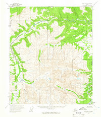
1956 Map of Eagle D-6
USGS Topo · Published 1966About this map
Charley River dominates the eastern drainage of this interior Alaskan wilderness, as mapped in the mid-1950s. The landscape is defined by the high elevations of the North Star Borough boundary and the intricate headwaters of several major creek systems. Tributaries such as Crescent Creek, Beverly Creek, and Moraine Creek carve through the high ridges, illustrating the natural drainage patterns of this unpopulated region. The survey also identifies the east-west Base Line, a critical reference for the Public Land Survey System during the territory's transition into statehood. These topographical details, captured through photogrammetry from mid-century aerial photographs, record the untouched character of the subarctic terrain before modern development or resource extraction altered the land.
Find a feature on this map
6 named features on this map. Tap any name to fly to it.
Don’t see what you’re looking for? This feature index may not catch every label — zoom into the map to look around manually.
Map Details
Editions of this 1956 Eagle D-6 Map
2 editions found
Other maps of this area

1950 · Big Delta
USGS Topo · 1:250,000

1951 · Big Delta
USGS Topo · 1:250,000

1951 · Charley River
USGS Topo · 1:250,000

1951 · Eagle
USGS Topo · 1:250,000

1951 · Circle
USGS Topo · 1:250,000

1955 · Circle A-1
USGS Topo · 1:63,360

1955 · Circle
USGS Topo · 1:250,000

1956 · Charley River A-5
USGS Topo · 1:63,360

1956 · Charley River A-6
USGS Topo · 1:63,360

1956 · Charley River
USGS Topo · 1:250,000