
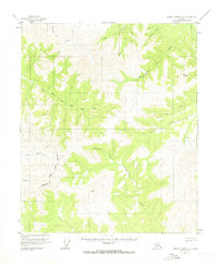
1956 Map of Charley River A-6
USGS Topo · Published 1960About this map
Salcha River and Birch Creek headwaters dominate this interior Alaskan landscape, which was photogrammetrically mapped in the mid-1950s. The survey reveals a vast network of drainages including Coal Creek, Sterling Creek, and Woodhopper Creek that carve through high-elevation terrain. This specific quadrangle covers a remote area of the Yukon-Koyukuk region characterized by the Yukon River South Fork, where many land lines remained unsurveyed and unmarked during the time of publication. The intricate contour work illustrates the complex drainage patterns of the northern wilderness before modern infrastructure touched these specific coordinates. Researchers can trace the courses of lesser-known waterways like Hanna Creek and Webber Creek as they appeared prior to the era of contemporary satellite mapping.
Find a feature on this map
12 named features on this map. Tap any name to fly to it.
Don’t see what you’re looking for? This feature index may not catch every label — zoom into the map to look around manually.
Map Details
Editions of this 1956 Charley River A-6 Map
2 editions found
Other maps of this area

1950 · Big Delta
USGS Topo · 1:250,000

1951 · Big Delta
USGS Topo · 1:250,000

1951 · Charley River
USGS Topo · 1:250,000

1951 · Eagle
USGS Topo · 1:250,000

1951 · Circle
USGS Topo · 1:250,000

1955 · Circle A-1
USGS Topo · 1:63,360

1955 · Circle B-1
USGS Topo · 1:63,360

1955 · Circle
USGS Topo · 1:250,000

1956 · Charley River B-6
USGS Topo · 1:63,360

1956 · Charley River A-5
USGS Topo · 1:63,360