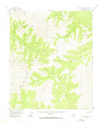
1956 Map of Charley River A-6
USGS Topo · Published 1973About this map
High peaks and a dense network of watercourses define this interior Alaskan landscape, which was photogrammetrically surveyed in 1951. Rising in the northeast, Mt Kathryn overlooks the headwaters of several drainages, including the northward-flowing Woodchopper Creek and Caribou Creek. The drainage patterns reveal a complex topography of ridges and valleys that feed into major regional systems, most notably the South Fork Birch Creek, which meanders through the central portion of the sheet. The presence of the North Star Borough Fairbanks boundary line in the southwest corner indicates the administrative limits of the region during this mid-century period. For the researcher, the map preserves the exact names and courses of numerous smaller tributaries such as Thanksgiving Creek, Coal Creek, and Sterling Creek, offering a clear look at the hydraulic landscape before significant modern changes. The terrain character shifts in the southern reaches toward the Salcha River and Willow Creek basins.
Find a feature on this map
15 named features on this map. Tap any name to fly to it.
Don’t see what you’re looking for? This feature index may not catch every label — zoom into the map to look around manually.
Map Details
Editions of this 1956 Charley River A-6 Map
2 editions found

Other maps of this area

1950 · Big Delta
USGS Topo · 1:250,000

1951 · Big Delta
USGS Topo · 1:250,000

1951 · Charley River
USGS Topo · 1:250,000

1951 · Eagle
USGS Topo · 1:250,000

1951 · Circle
USGS Topo · 1:250,000

1955 · Circle A-1
USGS Topo · 1:63,360

1955 · Circle B-1
USGS Topo · 1:63,360

1955 · Circle
USGS Topo · 1:250,000

1956 · Charley River B-6
USGS Topo · 1:63,360

1956 · Charley River A-5
USGS Topo · 1:63,360