
1956 Map of Charley River A-5
USGS Topo · Published 1960About this map
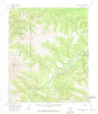
The Charley River carves a deep, winding path through this interior Alaskan wilderness, as documented in 1956. This landscape is defined by its complex drainage systems, where major tributaries like Sam Creek and Colorado Creek flow from high ridges toward the main river valley. In the western portion of the quadrangle, the prominent peaks of Twin Mountain dominate the local topography, standing as a primary landmark for the region. The map reflects a period of systematic aerial mapping by the Geological Survey, providing a clear record of the area's natural hydrology before significant human impact or modern development altered these remote drainages. Features like Dewey Creek and Coal Creek trace the intricate contours of the uplands, offering researchers an exact view of the watershed's configuration in the mid-1950s.
Find a feature on this map
13 named features on this map. Tap any name to fly to it.
Don’t see what you’re looking for? This feature index may not catch every label — zoom into the map to look around manually.
Map Details
Editions of this 1956 Charley River A-5 Map
2 editions found
Other maps of this area

1951 · Charley River
USGS Topo · 1:250,000

1951 · Eagle
USGS Topo · 1:250,000

1956 · Charley River B-6
USGS Topo · 1:63,360

1956 · Charley River A-4
USGS Topo · 1:63,360

1956 · Charley River B-5
USGS Topo · 1:63,360

1956 · Charley River A-6
USGS Topo · 1:63,360

1956 · Charley River B-4
USGS Topo · 1:63,360

1956 · Charley River
USGS Topo · 1:250,000
1956 · Eagle D-5
USGS Topo · 1:63,360
1956 · Eagle D-4
USGS Topo · 1:63,360