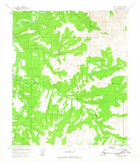
1956 Map of Eagle D-5
USGS Topo · Published 1965About this map
Hosford serves as a small waypoint in this high-altitude interior landscape, where the Charley River meanders through the western terrain. The survey, compiled from mid-1950s aerial photography, documents a region defined by its waterway network and the early markers of frontier habitation. Several locations labeled Cabin (Ruins) are scattered along the drainage basins of Eagle Creek and Copper Creek, indicating former sites of trapping or prospecting that had already begun to weather away by the time of the field annotation. The presence of the Base Line and the unique terrain feature known as Godge provide critical reference points for this largely unsurveyed territory, where the Bureau of Land Management predetermined land lines prior to physical marking.
Find a feature on this map
8 named features on this map. Tap any name to fly to it.
Don’t see what you’re looking for? This feature index may not catch every label — zoom into the map to look around manually.
Map Details
Editions of this 1956 Eagle D-5 Map
2 editions found
Other maps of this area

1951 · Charley River
USGS Topo · 1:250,000

1951 · Eagle
USGS Topo · 1:250,000

1956 · Charley River A-5
USGS Topo · 1:63,360

1956 · Charley River A-4
USGS Topo · 1:63,360

1956 · Charley River A-6
USGS Topo · 1:63,360

1956 · Charley River
USGS Topo · 1:250,000

1956 · Eagle C-6
USGS Topo · 1:63,360
1956 · Eagle D-4
USGS Topo · 1:63,360

1956 · Eagle C-5
USGS Topo · 1:63,360
1956 · Eagle D-6
USGS Topo · 1:63,360