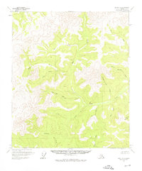
1956 Map of Eagle C-4
USGS Topo · Published 1976About this map
Gold Run Landing Strip serves as a remote focal point for this rugged interior landscape during the mid-1950s. The region is defined by a dense network of gold-prospecting drainages, where the presence of Cabins (Ruins) along Gold Run and Slate Creek indicates the remnants of earlier placer mining activity. The map reveals a cluster of creatively named waterways including Merry Christmas Creek, Fourth of July Creek, and Happy New Year Creek, suggesting the varied seasons during which early prospectors likely named their claims. Beyond these seasonal markers, the terrain is partitioned by features such as Pittsburgh Creek, Ruby Creek, and Ben Creek. This survey captures a moment in the territory's history when aviation provided the primary access to isolated resource frontiers before widespread road development reached these drainage basins.
Find a feature on this map
16 named features on this map. Tap any name to fly to it.
Don’t see what you’re looking for? This feature index may not catch every label — zoom into the map to look around manually.
Map Details
Editions of this 1956 Eagle C-4 Map
2 editions found
Other maps of this area

1951 · Eagle
USGS Topo · 1:250,000

1956 · Eagle D-3
USGS Topo · 1:63,360

1956 · Eagle B-3
USGS Topo · 1:63,360

1956 · Eagle B-5
USGS Topo · 1:63,360

1956 · Eagle B-4
USGS Topo · 1:63,360

1956 · Eagle C-3
USGS Topo · 1:63,360
1956 · Eagle D-5
USGS Topo · 1:63,360
1956 · Eagle D-4
USGS Topo · 1:63,360

1956 · Eagle C-5
USGS Topo · 1:63,360
1956 · Eagle C-4
USGS Topo · 1:63,360