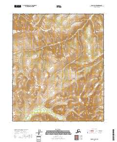
2018 Map of Eagle D-2 SW
USGS Topo · Published 2018About this map
The Mertie Mountains dominate the northeastern reaches of this topographic study, where the high-altitude terrain shapes a landscape defined by significant drainage systems. This interior Alaskan environment is characterized by sharp relief and the headwaters of several key waterways, including Mogul Cr and Bryant Cr. The presence of Mt Eldridge in the southern portion of the quadrangle provides a prominent landmark for navigating the high ridges that separate these creek basins.
Find a feature on this map
12 named features on this map. Tap any name to fly to it.
Don’t see what you’re looking for? This feature index may not catch every label — zoom into the map to look around manually.
Map Details
Editions of this 2018 Eagle D-2 SW Map
This is the sole edition of this map. No revisions or reprints were ever made.
Other maps of this area

1899 · Fortymile
USGS Topo · 1:250,000

1951 · Eagle
USGS Topo · 1:250,000

1956 · Eagle D-2
USGS Topo · 1:63,360

1956 · Eagle C-2
USGS Topo · 1:63,360

1956 · Eagle D-3
USGS Topo · 1:63,360

1956 · Eagle C-3
USGS Topo · 1:63,360

1957 · Eagle
USGS Topo · 1:250,000
2018 · Eagle D-2 SE
USGS Topo · 1:25,000
2018 · Eagle C-3 NE
USGS Topo · 1:25,000
2018 · Eagle C-2 NE
USGS Topo · 1:25,000