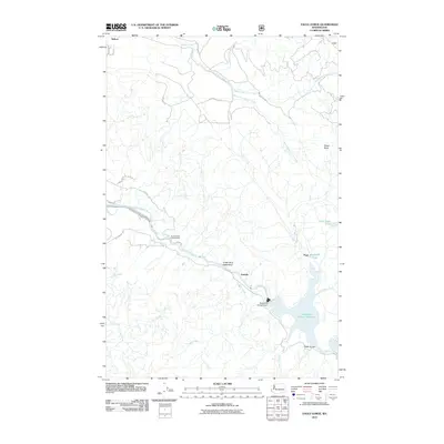
2011 Map of Eagle Gorge
USGS Topo · Published 2011About this map
The Green River corridor in King County is the central focus of this 2011 survey, showing the critical infrastructure of the Tacoma Water Supply Intake and the Howard A Hanson Dam. The landscape is dominated by the Green River Watershed and its complex network of tributaries, including Taylor Creek and its various forks. Small settlements and points like Selleck, Lemolo, and the namesake Eagle Gorge appear alongside resource-related features such as Page Mill Pond. The terrain reaches a notable height at Ghost Point, overlooking a region defined by its managed water resources and forestry access roads. The Howard A Hanson Reservoir fills the southeastern portion of the sheet, where Charley Creek and Piling Creek feed into the impounded river.
Find a feature on this map
32 named features on this map. Tap any name to fly to it.
Don’t see what you’re looking for? This feature index may not catch every label — zoom into the map to look around manually.
Map Details
Editions of this 2011 Eagle Gorge Map
This is the sole edition of this map. No revisions or reprints were ever made.
Other maps of this area

1913 · Cedar Lake
USGS Topo · 1:125,000

1953 · North Bend
USGS Topo · 1:24,000

1953 · Hobart
USGS Topo · 1:24,000

1953 · Eagle Gorge
USGS Topo · 1:24,000

1953 · Cumberland
USGS Topo · 1:24,000

1956 · Greenwater
USGS Topo · 1:62,500

1956 · Enumclaw
USGS Topo · 1:62,500
1956 · Enumclaw
USGS Topo · 1:24,000

1957 · Wenatchee
USGS Topo · 1:250,000

1960 · Bandera
USGS Topo · 1:62,500