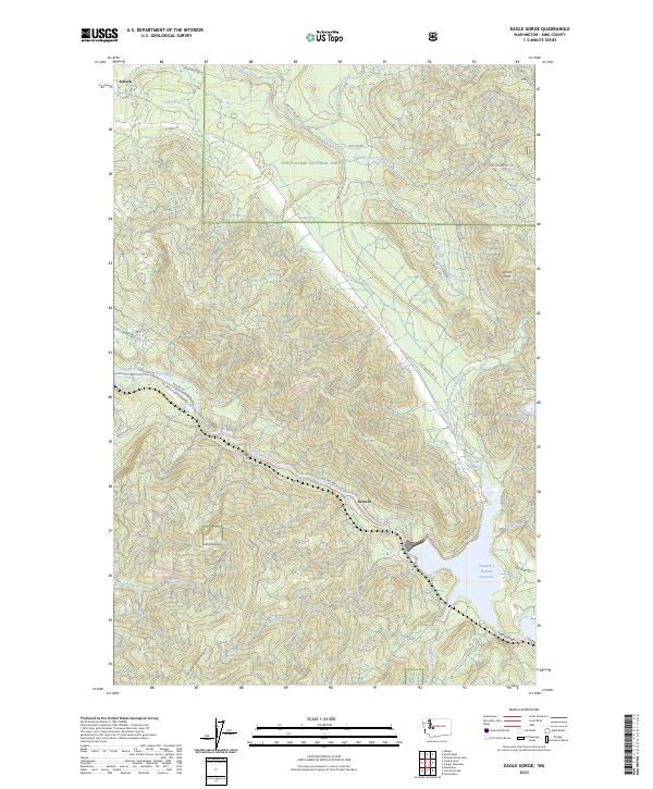
2023 Map of Eagle Gorge
USGS Topo · Published 2023About this map
Selleck sits at the northwestern edge of this landscape, marking the transition from settled King County towards the timberlands of the Snoqualmie National Forest. The central geography is dominated by the steep drainage systems of Taylor Creek and its many forks, which cut deep through the terrain towards the Green River. To the southeast, the Howard A Hanson Reservoir and the narrowing of Eagle Gorge indicate the significance of water management and natural topographic bottlenecks in this region. Local industry and land use are evidenced by the network of forestry roads and the presence of Page Mill Pond near the settlement of Lemolo. Further south, the high ridge of Grass Mountain defines the southern boundary, overseeing a complex network of tributaries including Bear Creek, Coal Creek, and Charley Creek that feed into the primary river systems.
Find a feature on this map
45 named features on this map. Tap any name to fly to it.
Don’t see what you’re looking for? This feature index may not catch every label — zoom into the map to look around manually.
Map Details
Editions of this 2023 Eagle Gorge Map
This is the sole edition of this map. No revisions or reprints were ever made.
Other maps of this area

1913 · Cedar Lake
USGS Topo · 1:125,000

1953 · North Bend
USGS Topo · 1:24,000

1953 · Hobart
USGS Topo · 1:24,000

1953 · Eagle Gorge
USGS Topo · 1:24,000

1953 · Cumberland
USGS Topo · 1:24,000

1956 · Greenwater
USGS Topo · 1:62,500

1956 · Enumclaw
USGS Topo · 1:62,500
1956 · Enumclaw
USGS Topo · 1:24,000

1957 · Wenatchee
USGS Topo · 1:250,000

1960 · Bandera
USGS Topo · 1:62,500