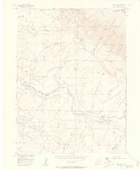
1955 Map of Eagle Hill
USGS Topo · Published 1957About this map
The North McCallum Oil Field and the nearby Battleship Oil Field define the industrial landscape of this Jackson County region in the mid-1950s. Located in the high country where the Routt National Forest meets the Colorado State Forest, the terrain is marked by the winding path of the Canadian River and its numerous tributaries. These water sources supported a network of remote holdings, including the Dowell Homestead and the Dwinell Ranch, illustrating the intersection of energy extraction and high-altitude ranching.
Find a feature on this map
30 named features on this map. Tap any name to fly to it.
Don’t see what you’re looking for? This feature index may not catch every label — zoom into the map to look around manually.
Map Details
Editions of this 1955 Eagle Hill Map
4 editions found
Other maps of this area

1950 · Northgate
USGS Topo · 1:24,000

1950 · Kings Canyon
USGS Topo · 1:24,000

1952 · Northgate
USGS Topo · 1:24,000

1952 · Kings Canyon
USGS Topo · 1:24,000

1954 · Craig
USGS Topo · 1:250,000

1955 · Old Roach
USGS Topo · 1:24,000

1955 · Eagle Hill
USGS Topo · 1:24,000

1955 · Shipman Mountain
USGS Topo · 1:24,000

1955 · Gould NW
USGS Topo · 1:24,000

1955 · Walden
USGS Topo · 1:24,000