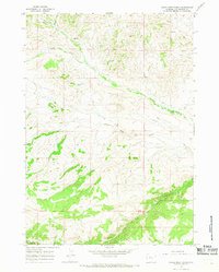
1965 Map of Eagle Nest Ranch
USGS Topo · Published 1968About this map
Eagle Nest Ranch sits near the confluence of the North Fork and South Fork of the watershed, anchoring a landscape defined by the intricate drainage of Owl Creek. The 1960s terrain is characterized by the convergence of the Middle Fork and W Fork Owl Creek, where the hydrology dictates the patterns of early ranching and transport. A notable administrative feature is the Wind River Indian Reservation Boundary, which cuts across the southern portion of the quadrangle. The sparse infrastructure consists primarily of a Jeep Trail, illustrating the remote nature of this part of Hot Springs County during the mid-20th century. Localized water sources like Spring and Springs are mapped with precision, serving as vital landmarks in an area where water management was essential for both livestock and settlement.
Find a feature on this map
10 named features on this map. Tap any name to fly to it.
Don’t see what you’re looking for? This feature index may not catch every label — zoom into the map to look around manually.
Map Details
Editions of this 1965 Eagle Nest Ranch Map
2 editions found
Other maps of this area

1904 · Kirwin
USGS Topo · 1:125,000

1906 · Kirwin
USGS Topo · 1:125,000

1952 · Antelope Ridge
USGS Topo · 1:24,000

1952 · Bargee
USGS Topo · 1:24,000

1955 · Thermopolis
USGS Topo · 1:250,000

1956 · Milk Creek
USGS Topo · 1:24,000

1956 · Twentyone Creek
USGS Topo · 1:24,000

1958 · Thermopolis
USGS Topo · 1:250,000

1962 · Thermopolis
USGS Topo · 1:250,000
1965 · Anchor Reservoir
USGS Topo · 1:24,000