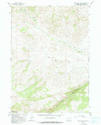
1965 Map of Eagle Nest Ranch
USGS Topo · Published 1991About this map
Eagle Nest Ranch sits at the confluence of several drainages in the Owl Creek Mountains during the mid-1960s. This high-altitude landscape is defined by the branching waters of North Fork Owl Creek, Middle Fork Owl Creek, and South Fork Owl Creek, which carve through the terrain and meet near the eastern edge of the survey. The southern portion of the quadrangle is occupied by the Wind River Indian Reservation Boundary, illustrating the intersection of private ranching interests and tribal lands in this part of Wyoming.
Find a feature on this map
9 named features on this map. Tap any name to fly to it.
Don’t see what you’re looking for? This feature index may not catch every label — zoom into the map to look around manually.
Map Details
Editions of this 1965 Eagle Nest Ranch Map
2 editions found
Other maps of this area

1904 · Kirwin
USGS Topo · 1:125,000

1906 · Kirwin
USGS Topo · 1:125,000

1952 · Antelope Ridge
USGS Topo · 1:24,000

1952 · Bargee
USGS Topo · 1:24,000

1955 · Thermopolis
USGS Topo · 1:250,000

1956 · Milk Creek
USGS Topo · 1:24,000

1956 · Twentyone Creek
USGS Topo · 1:24,000

1958 · Thermopolis
USGS Topo · 1:250,000

1962 · Thermopolis
USGS Topo · 1:250,000
1965 · Eagle Nest Ranch
USGS Topo · 1:24,000