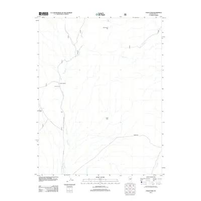
2012 Map of Eagle Pass
USGS Topo · Published 2012About this map
Daugherty Ranch serves as a primary point of human activity in this arid landscape of Nye County, Nevada. The terrain is defined by a network of drainage systems and isolated water sources, most notably the winding course of Willow Creek which travels south through the western portion of the quadrangle. High points like Eagle Peak and the namesake Eagle Pass provide topographical landmarks for travelers navigating the region's complex system of canyons and flats. The presence of multiple springs, including Burnt Cabin Spring, Indian Garden Spring, and Knoll Spring, indicates the vital importance of these specific water locations in a desert environment. Transportation is facilitated by the Natl Forest Develop Road 006 Rd, which follows the creek valley, connecting the ranch to the higher passes and surrounding mountain terrain.
Find a feature on this map
21 named features on this map. Tap any name to fly to it.
Don’t see what you’re looking for? This feature index may not catch every label — zoom into the map to look around manually.
Map Details
Editions of this 2012 Eagle Pass Map
This is the sole edition of this map. No revisions or reprints were ever made.
Other maps of this area

1956 · Tonopah
USGS Topo · 1:250,000

1959 · Tonopah
USGS Topo · 1:250,000

1962 · Tonopah
USGS Topo · 1:250,000

1967 · Upper Fish Lake
USGS Topo · 1:24,000

1968 · Tybo
USGS Topo · 1:62,500

1968 · Morey Peak
USGS Topo · 1:62,500
1968 · Flagstaff Mtn.
USGS Topo · 1:24,000
1968 · Little Fish Lake
USGS Topo · 1:24,000
1971 · McIntyre Summit
USGS Topo · 1:24,000

1971 · Barley Creek
USGS Topo · 1:24,000