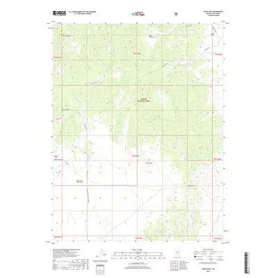
2018 Map of Eagle Pass
USGS Topo · Published 2018About this map
Toiyabe National Forest dominates this high-elevation landscape in Nye County, where the southern reaches of the Monitor Range transition into the expansive West Stone Cabin Valley. The map documents a rugged network of water sources essential for survival in the Great Basin, including Burnt Cabin Spring, Indian Garden Spring, and Knoll Spring. These springs are often paired with eponymous landmarks like Burnt Cabin Flat and the Indian Garden drainage, suggesting a history of seasonal habitation or ranching camps. Transportation is defined by primitive tracks such as Spring Road and the Cutoff, which navigate the steep terrain around Eagle Peak and through the namesake Eagle Pass. The presence of several named canyons, including Horse Canyon and House Canyon, illustrates the complex drainage system feeding into Willow Creek and Hot Cr.
Find a feature on this map
29 named features on this map. Tap any name to fly to it.
Don’t see what you’re looking for? This feature index may not catch every label — zoom into the map to look around manually.
Map Details
Editions of this 2018 Eagle Pass Map
This is the sole edition of this map. No revisions or reprints were ever made.
Other maps of this area

1956 · Tonopah
USGS Topo · 1:250,000

1959 · Tonopah
USGS Topo · 1:250,000

1962 · Tonopah
USGS Topo · 1:250,000

1967 · Upper Fish Lake
USGS Topo · 1:24,000

1968 · Tybo
USGS Topo · 1:62,500

1968 · Morey Peak
USGS Topo · 1:62,500
1968 · Flagstaff Mtn.
USGS Topo · 1:24,000
1968 · Little Fish Lake
USGS Topo · 1:24,000
1971 · McIntyre Summit
USGS Topo · 1:24,000

1971 · Barley Creek
USGS Topo · 1:24,000