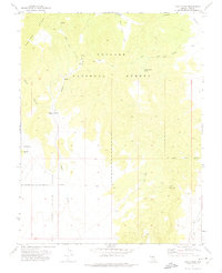
1971 Map of Eagle Pass
USGS Topo · Published 1975About this map
Toiyabe National Forest dominates this high-altitude landscape in central Nevada, where the slopes of the Monitor Range descend into the broad expanse of Stone Cabin Valley. The mapping reveals a terrain defined by its water sources, with numerous springs such as Knoll Spring and Burnt Cabin Spring providing critical points of reference in an otherwise arid environment. Evidence of human habitation and land use is centered around the Daugherty Ranch, located near the mouth of House Canyon. The network of travel through these mountains is preserved via several Jeep Trails and a Pack Trail that crosses through Eagle Pass, connecting the high ridges with the valley floor near Willow Creek. This 1970s survey captures the region's character as a managed wilderness area where cattle ranching and recreational access intersect along the forest boundaries.
Find a feature on this map
21 named features on this map. Tap any name to fly to it.
Don’t see what you’re looking for? This feature index may not catch every label — zoom into the map to look around manually.
Map Details
Editions of this 1971 Eagle Pass Map
This is the sole edition of this map. No revisions or reprints were ever made.
Other maps of this area

1956 · Tonopah
USGS Topo · 1:250,000

1959 · Tonopah
USGS Topo · 1:250,000

1962 · Tonopah
USGS Topo · 1:250,000

1967 · Upper Fish Lake
USGS Topo · 1:24,000

1968 · Tybo
USGS Topo · 1:62,500

1968 · Morey Peak
USGS Topo · 1:62,500
1968 · Flagstaff Mtn.
USGS Topo · 1:24,000
1968 · Little Fish Lake
USGS Topo · 1:24,000
1971 · McIntyre Summit
USGS Topo · 1:24,000

1971 · Barley Creek
USGS Topo · 1:24,000