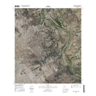
2016 Map of Eagle Pass SW
USGS Topo · Published 2016About this map
The Rio Grande serves as a dominant geographical and political boundary here, defining the winding international border between Texas and the United States of America and Mexico. In the northern portion of the quadrangle, the community of Rosita shows a structured network of residential streets such as Rosita Valley Rd and Lisa Blvd, illustrating the expansion of settlements along the river's edge. This 2016 survey highlights the intersection of rural Texas land use and organized residential pockets like Riverside Acres and Quail Valley. Further south, the landscape opens into more sparse terrain, drained by Rosita Cr as it flows toward the main river channel. Near the southern edge of the sheet, El Indio Farms Lake provides a distinct point of hydrographic interest amidst the brush and arid landscape typical of Maverick County.
Find a feature on this map
26 named features on this map. Tap any name to fly to it.
Don’t see what you’re looking for? This feature index may not catch every label — zoom into the map to look around manually.
Map Details
Editions of this 2016 Eagle Pass SW Map
This is the sole edition of this map. No revisions or reprints were ever made.
Other maps of this area

1940 · Eagle Pass
USGS Topo · 1:62,500

1957 · Indio Creek
USGS Topo · 1:62,500

1958 · Eagle Pass
USGS Topo · 1:250,000

1965 · Eagle Pass
USGS Topo · 1:250,000
1982 · Eagle Pass NE
USGS Topo · 1:24,000
1983 · Eagle Pass East
USGS Topo · 1:24,000
1983 · Eagle Pass West
USGS Topo · 1:24,000
1983 · El Indio
USGS Topo · 1:24,000
1983 · Indio Creek
USGS Topo · 1:24,000
1983 · Eagle Pass SW
USGS Topo · 1:24,000
Featured Places
- Rosita, TX
- Riverside Acres Colonia, TX
- Loma Linda Ranchettes Colonia, TX
- Loma Linda Number 3 Colonia, TX