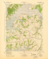
1944 Map of Earleville
USGS Topo · Published 1944About this map
Elk Neck State Park dominates the northwest corner of this Cecil County peninsula, where the Elk River meets the Chesapeake Bay. In the mid-1940s, this landscape was defined by its deep estuaries and agricultural necks, with small settlements like Earleville and Town Point serving as local hubs. The map reveals a network of rural roads such as Veazey Neck Road and Pearce Neck Road that connect isolated farms to the water's edge.
Find a feature on this map
55 named features on this map. Tap any name to fly to it.
Don’t see what you’re looking for? This feature index may not catch every label — zoom into the map to look around manually.
Map Details
Editions of this 1944 Earleville Map
This is the sole edition of this map. No revisions or reprints were ever made.
Other maps of this area

1898 · Elkton
USGS Topo · 1:62,500

1898 · Tolchester
USGS Topo · 1:125,000

1899 · Dover
USGS Topo · 1:125,000

1900 · Elkton
USGS Topo · 1:62,500

1900 · Cecilton
USGS Topo · 1:62,500

1900 · Havre De Grace
USGS Topo · 1:62,500

1900 · Betterton
USGS Topo · 1:62,500

1903 · Tolchester
USGS Topo · 1:125,000

1906 · Dover
USGS Topo · 1:125,000

1908 · Tolchester
USGS Topo · 1:125,000