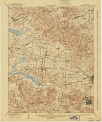
1909 Map of Earlington
USGS Topo · Published 1940About this map
Earlington and the county seat of Madisonville serve as primary hubs in this western Kentucky landscape, where the coal-driven economy of the early twentieth century is already taking shape. The Louisville and Nashville RR and the Illinois Central RR provide critical transport for the region, while the Morganfield Branch cuts across the center. Rural life is anchored by an extensive network of small communities and social institutions, including Beulah Silent Run PO and Circle City. Numerous rural schools such as Munn School and Yarbro School, alongside country churches like Burnt Mill Church, dot the terrain. The landscape is defined by the wetlands surrounding Clear Creek and Pond Creek, which contrast with the higher elevations of Sugar Ridge and Fort Ridge.
Find a feature on this map
70 named features on this map. Tap any name to fly to it.
Don’t see what you’re looking for? This feature index may not catch every label — zoom into the map to look around manually.
Map Details
Editions of this 1909 Earlington Map
3 editions found
Other maps of this area

1906 · Sebree
USGS Topo · 1:62,500

1907 · Earlington
USGS Topo · 1:48,000

1907 · Morganfield
USGS Topo · 1:62,500

1908 · Calhoun
USGS Topo · 1:62,500

1908 · Princeton
USGS Topo · 1:62,500

1909 · Dawson Springs
USGS Topo · 1:48,000

1909 · Earlington
USGS Topo · 1:62,500

1909 · Madisonville
USGS Topo · 1:62,500

1909 · Providence
USGS Topo · 1:62,500

1910 · Princeton
USGS Topo · 1:62,500