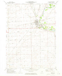
1971 Map of Earlville
USGS Topo · Published 1973About this map
Earlville serves as the central hub of this LaSalle County landscape, where the Chicago and North Western and Burlington Northern railroads intersect. The town's mid-century infrastructure is visible in details like the High Sch, Water Tank, and a Drive-in Theater located on the southwestern edge of the settlement. Beyond the town grid, the landscape is defined by the Old Indian Treaty Boundary, which cuts diagonally across the prairie between the townships of Earl and Ophir.
Find a feature on this map
28 named features on this map. Tap any name to fly to it.
Don’t see what you’re looking for? This feature index may not catch every label — zoom into the map to look around manually.
Map Details
Editions of this 1971 Earlville Map
This is the sole edition of this map. No revisions or reprints were ever made.
Other maps of this area

1892 · Ottawa
USGS Topo · 1:62,500

1893 · Lasalle
USGS Topo · 1:62,500

1911 · La Salle
USGS Topo · 1:62,500

1913 · La Salle
USGS Topo · 1:62,500

1915 · Ottawa
USGS Topo · 1:62,500

1946 · Ottawa
USGS Topo · 1:62,500

1947 · La Salle
USGS Topo · 1:62,500

1951 · Earlville
USGS Topo · 1:62,500

1952 · Mendota
USGS Topo · 1:62,500

1958 · Aurora
USGS Topo · 1:250,000