
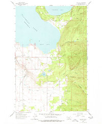
1964 Map of East Bay
USGS Topo · Published 1966About this map
Polson serves as the gateway to the southern end of the lake on this mid-century topographic survey. The landscape is defined by the significant transition from the waters of Flathead Lake and the sheltered East Bay to the steep rises of Minesinger Ridge. The area's physical geography is intricately mapped, showing the complex drainage systems of Hellroaring Creek, Centipede Creek, and Skidoo Creek as they flow toward the shoreline. Localized landmarks like Finley Point and Turtle Lake provide specific points of reference for the varied terrain. This survey also records the vital infrastructure of the era, including the Northern Pacific railroad line, the Pablo Feeder Canal, and various gravel pits, which illustrate the industrial and agricultural activity supporting the local community during the 1960s.
Find a feature on this map
1 named feature on this map. Tap any name to fly to it.
Don’t see what you’re looking for? This feature index may not catch every label — zoom into the map to look around manually.
Map Details
Editions of this 1964 East Bay Map
2 editions found
Other maps of this area

1920 · Flathead Lake
USGS Topo · 1:125,000

1955 · Choteau
USGS Topo · 1:250,000

1956 · Wallace
USGS Topo · 1:250,000

1957 · Choteau
USGS Topo · 1:250,000

1958 · Choteau
USGS Topo · 1:250,000

1960 · Wallace
USGS Topo · 1:250,000

1962 · Choteau
USGS Topo · 1:250,000

1964 · Bull Island
USGS Topo · 1:24,000

1964 · Wild Horse Island
USGS Topo · 1:24,000

1964 · Polson
USGS Topo · 1:24,000