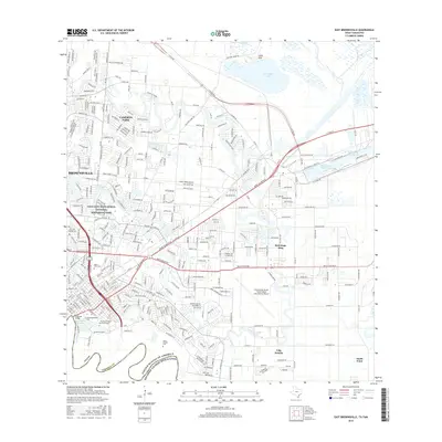
2016 Map of East Brownsville
USGS Topo · Published 2016About this map
The Rio Grande serves as the international boundary on this survey of Brownsville, Texas, where the urban grid meets the winding oxbows and resacas of the borderlands. Significant local history is preserved at the Palo Alto Battlefield National Historical Park in the northwest, while the southeastern reaches show the industrial and maritime infrastructure of the Brownsville Ship Channel and the Intracoastal Waterway. Education and transit hubs are central to this landscape, featuring Texas Southmost Coll and The Univ of Texas at Brownsville near the river, alongside the Brownsville/South Padre Island International Airport. Several historical burial grounds, including the Old City Cem and Santa Rosalia Cem, provide valuable landmarks for genealogical research within the city's expanding residential footprints like Cameron Park and Reid Hope King.
Find a feature on this map
329 named features on this map. Tap any name to fly to it.
Don’t see what you’re looking for? This feature index may not catch every label — zoom into the map to look around manually.
Map Details
Editions of this 2016 East Brownsville Map
This is the sole edition of this map. No revisions or reprints were ever made.
Other maps of this area

1929 · Palmito Hill
USGS Topo · 1:24,000

1929 · Laguna Vista
USGS Topo · 1:24,000

1930 · Los Fresnos
USGS Topo · 1:24,000

1930 · West Brownsville
USGS Topo · 1:24,000

1930 · Barreda
USGS Topo · 1:24,000

1930 · East Brownsville
USGS Topo · 1:24,000

1936 · Los Fresnos
USGS Topo · 1:31,680
1936 · West Brownsville
USGS Topo · 1:31,680

1936 · Palmito Hill
USGS Topo · 1:31,680
1936 · Barreda
USGS Topo · 1:31,680