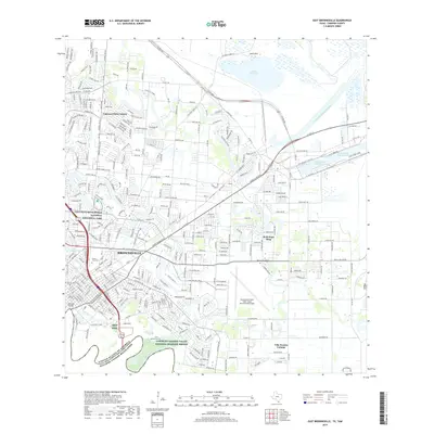
2019 Map of East Brownsville
USGS Topo · Published 2019About this map
The Rio Grande forms a winding international boundary at the southern edge of this modern landscape, where the Gateway Bridge connects Brownsville to the border. This 2019 survey documents a complex intersection of history and industry, from the sprawling Palo Alto Battlefield National Historical Park in the northwest to the heavy maritime infrastructure of the Brownsville Ship Channel and Intracoastal Waterway in the east.
Find a feature on this map
43 named features on this map. Tap any name to fly to it.
Don’t see what you’re looking for? This feature index may not catch every label — zoom into the map to look around manually.
Map Details
Editions of this 2019 East Brownsville Map
This is the sole edition of this map. No revisions or reprints were ever made.
Other maps of this area

1929 · Palmito Hill
USGS Topo · 1:24,000

1929 · Laguna Vista
USGS Topo · 1:24,000

1930 · Los Fresnos
USGS Topo · 1:24,000

1930 · West Brownsville
USGS Topo · 1:24,000

1930 · Barreda
USGS Topo · 1:24,000

1930 · East Brownsville
USGS Topo · 1:24,000

1936 · Los Fresnos
USGS Topo · 1:31,680
1936 · West Brownsville
USGS Topo · 1:31,680

1936 · Palmito Hill
USGS Topo · 1:31,680
1936 · Barreda
USGS Topo · 1:31,680