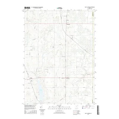
2016 Map of East Claridon
USGS Topo · Published 2016About this map
The E Br Cuyahoga River and its upper tributaries dominate this portion of Geauga County, carving through a landscape defined by small rural hubs and agricultural crossroads. The community of East Claridon sits near the headwaters of the river's eastern branch, while the East Br Reservoir and Spring Lake highlight the area's complex water management. Geographers and local historians can trace the historical layout of several burial grounds, including the East Claridon Cem and the two distinct sites at Huntsburg Center Cem and Huntsburg Cem. This 2016 survey captures the persistent rural character of the region, featuring Rick's Airport as a notable local landmark. Further east, the village of Montville and its eponymous Montville Ditch mark the transition toward the Ashtabula County line, illustrating the drainage patterns that have shaped the township's development over generations.
Find a feature on this map
59 named features on this map. Tap any name to fly to it.
Don’t see what you’re looking for? This feature index may not catch every label — zoom into the map to look around manually.
Map Details
Editions of this 2016 East Claridon Map
This is the sole edition of this map. No revisions or reprints were ever made.
Other maps of this area

1904 · Chardon
USGS Topo · 1:62,500

1905 · Bristolville
USGS Topo · 1:62,500

1905 · Garrettsville
USGS Topo · 1:62,500

1905 · Jefferson
USGS Topo · 1:62,500

1906 · Chardon
USGS Topo · 1:62,500

1907 · Bristolville
USGS Topo · 1:62,500

1907 · Jefferson
USGS Topo · 1:62,500

1907 · Garrettsville
USGS Topo · 1:62,500

1950 · Cleveland
USGS Topo · 1:250,000

1952 · West Farmington
USGS Topo · 1:24,000
Featured Places
- Hambden Township, OH
- Mesopotamia Township, OH
- Burton Township, OH
- Hartsgrove Township, OH
- Windsor Township, OH