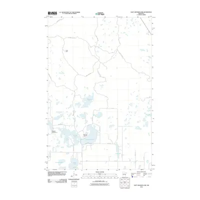
2010 Map of East Crooked Lake
USGS Topo · Published 2010About this map
East Crooked Lake and its surrounding wetlands anchor this recreational and timber landscape in Hubbard County. By the early 21st century, the area had developed a distinct character defined by seasonal tourism and forest management. Established retreats like Whispering Pines Resort and Campground and Breezy Pines Resort and Campground reflect the region's long-standing draw for vacationers and sportsmen. The map documents an extensive network of forestry roads, such as Steam Boat Forest Rd and Akeley Cutoff Rd, which segment the dense woods around Waboose Lake and Coon Lake. A notable landmark is the Thorpe Lookout Tower, situated at a high point in the northwestern quadrant. The transition from public forest tracks to local routes like Mantrap Twp 14 illustrates the intersection of wilderness management and residential settlement near the lake shores.
Find a feature on this map
34 named features on this map. Tap any name to fly to it.
Don’t see what you’re looking for? This feature index may not catch every label — zoom into the map to look around manually.
Map Details
Editions of this 2010 East Crooked Lake Map
This is the sole edition of this map. No revisions or reprints were ever made.
Other maps of this area

1953 · Brainerd
USGS Topo · 1:250,000

1954 · Bemidji
USGS Topo · 1:250,000

1957 · Brainerd
USGS Topo · 1:250,000

1957 · Bemidji
USGS Topo · 1:250,000

1958 · Bemidji
USGS Topo · 1:250,000

1958 · Brainerd
USGS Topo · 1:250,000

1965 · Brainerd
USGS Topo · 1:250,000

1970 · Nevis
USGS Topo · 1:24,000

1970 · Dorset
USGS Topo · 1:24,000
1970 · Crystal Lake
USGS Topo · 1:24,000