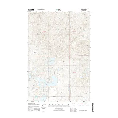
2016 Map of East Crooked Lake
USGS Topo · Published 2016About this map
Glacial lakes and dense woodland roads define this Hubbard County landscape during the mid-2010s. Central to the map is the large expanse of E Crooked Lake, which sits adjacent to W Crooked Lake and the smaller Coon Lake. To the north, Waboose Lake is surrounded by a network of timber and access roads such as Steamboat Forest Rd and Refuge Forest Rd. The N Country National Scenic Trail winds through the northern and eastern sections of the terrain, crossing the Akeley Cutoff. In the southern reaches, the waters of Crow Wing Lake and Eleventh Crow Wing Lake mark the lake-strewn topography typical of the region. This 2016 survey captures the area's intricate balance of public forest navigation and significant freshwater bodies before further modern shoreline development.
Find a feature on this map
36 named features on this map. Tap any name to fly to it.
Don’t see what you’re looking for? This feature index may not catch every label — zoom into the map to look around manually.
Map Details
Editions of this 2016 East Crooked Lake Map
This is the sole edition of this map. No revisions or reprints were ever made.
Other maps of this area
1953 · Brainerd
USGS Topo · 1:250,000

1954 · Bemidji
USGS Topo · 1:250,000
1957 · Brainerd
USGS Topo · 1:250,000

1957 · Bemidji
USGS Topo · 1:250,000

1958 · Bemidji
USGS Topo · 1:250,000
1958 · Brainerd
USGS Topo · 1:250,000
1965 · Brainerd
USGS Topo · 1:250,000
1970 · Nevis
USGS Topo · 1:24,000
1970 · Dorset
USGS Topo · 1:24,000
1970 · Crystal Lake
USGS Topo · 1:24,000