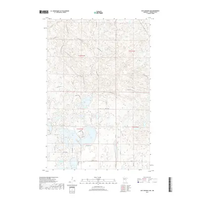
2019 Map of East Crooked Lake
USGS Topo · Published 2019About this map
Glacial lakes and dense woodland roads dominate this portion of Hubbard County, where the intricate shoreline of Crooked Lake and its neighbor East Crooked Lake form a central landmark. The landscape is defined by a network of specialized routes, including the N Country National Scenic Trail which winds through the northern forest sections. Local transit is supported by a mix of forestry roads like Steamboat Forest Rd and Thorpe Tower Forest Rd, alongside established local connectors such as Co Hwy 2.
Find a feature on this map
41 named features on this map. Tap any name to fly to it.
Don’t see what you’re looking for? This feature index may not catch every label — zoom into the map to look around manually.
Map Details
Editions of this 2019 East Crooked Lake Map
This is the sole edition of this map. No revisions or reprints were ever made.
Other maps of this area
1953 · Brainerd
USGS Topo · 1:250,000

1954 · Bemidji
USGS Topo · 1:250,000
1957 · Brainerd
USGS Topo · 1:250,000

1957 · Bemidji
USGS Topo · 1:250,000

1958 · Bemidji
USGS Topo · 1:250,000
1958 · Brainerd
USGS Topo · 1:250,000
1965 · Brainerd
USGS Topo · 1:250,000
1970 · Nevis
USGS Topo · 1:24,000
1970 · Dorset
USGS Topo · 1:24,000
1970 · Crystal Lake
USGS Topo · 1:24,000