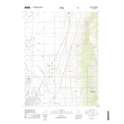
2018 Map of East Ely
USGS Topo · Published 2018About this map
Steptoe Valley forms the central corridor of this White Pine County landscape, where the high desert floor meets the rising slopes of the Duck Creek Range. The map documents a significant intersection of aviation and industry, anchored by Ely Airport / Yelland Field and the nearby Baltimore Mill. The southern portion of the sheet reveals the early 21st-century residential and commercial layout of East Ely and its neighboring settlement of Ely, including local landmarks like Golf Course Rd and Rodeo Ln. Water remains a vital element of this arid region, as evidenced by several thermal and freshwater sources including Lackawanna Springs, Warm Spring, and Ely Warm Springs. To the east, the boundary of the Humboldt National Forest marks the transition into more mountainous terrain, while named junctions like McGill Junction and smaller localities such as Lavon and Mosier detail the rural road network connecting these Great Basin communities.
Find a feature on this map
74 named features on this map. Tap any name to fly to it.
Don’t see what you’re looking for? This feature index may not catch every label — zoom into the map to look around manually.
Map Details
Editions of this 2018 East Ely Map
This is the sole edition of this map. No revisions or reprints were ever made.
Other maps of this area

1952 · Ely
USGS Topo · 1:125,000

1956 · Ely
USGS Topo · 1:250,000

1958 · McGill
USGS Topo · 1:24,000

1958 · Ruth
USGS Topo · 1:24,000

1958 · East Ely
USGS Topo · 1:24,000

1958 · Comins Lake
USGS Topo · 1:24,000

1958 · Ely
USGS Topo · 1:62,500

1958 · McGill
USGS Topo · 1:62,500

1958 · Ely
USGS Topo · 1:24,000

1959 · Ely
USGS Topo · 1:250,000