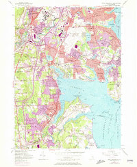
1957 Map of East Greenwich
USGS Topo · Published 1973About this map
Theodore Francis Green Memorial State Airport dominates the northern landscape of this Rhode Island coast, reflecting the mid-century expansion of aviation infrastructure in Warwick. The map illustrates a dense network of suburban and coastal settlements, where historic centers like East Greenwich and Apponaug are connected by the venerable Post Road and the Penn Central rail line. To the south, the transition from urbanized blocks to open coastal lands is marked by the expansive Goddard Memorial State Park on Potowomut Neck.
Find a feature on this map
116 named features on this map. Tap any name to fly to it.
Don’t see what you’re looking for? This feature index may not catch every label — zoom into the map to look around manually.
Map Details
Editions of this 1957 East Greenwich Map
4 editions found
Other maps of this area

1887 · Providence
USGS Topo · 1:62,500

1889 · Providence
USGS Topo · 1:62,500

1889 · Burrillville
USGS Topo · 1:62,500

1890 · Narragansett Bay
USGS Topo · 1:62,500

1890 · Kent
USGS Topo · 1:62,500

1892 · Narragansett Bay
USGS Topo · 1:62,500

1894 · Burrillville
USGS Topo · 1:62,500

1894 · Kent
USGS Topo · 1:62,500

1894 · Providence
USGS Topo · 1:62,500

1915 · Burrillville
USGS Topo · 1:62,500