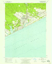
1956 Map of East Hampton
USGS Topo · Published 1958About this map
East Hampton and its surrounding hamlets are captured here in the mid-1950s, showing a landscape defined by historic coastal lanes and established maritime neighborhoods. The map details the transition from the village center toward the dunes, with significant landmarks such as Waters Chapel and St. Philomena's Cem grounding the local social history. The southern coastline is marked by a sequence of prominent coastal ponds, including Georgica Pond, Hook Pond, and Wainscott Pond, which separate the residential developments from the Atlantic Ocean. Inland, the road network follows historic routes like Northwest Path and Stephen Hands Path, reflecting centuries of land use. From the industrial Gravel Pits to the recreational corridors near the East Hampton Airport, the survey documents a period of postwar stability before the significant expansion of modern estates changed the character of these South Fork communities.
Find a feature on this map
60 named features on this map. Tap any name to fly to it.
Don’t see what you’re looking for? This feature index may not catch every label — zoom into the map to look around manually.
Map Details
Editions of this 1956 East Hampton Map
4 editions found
Other maps of this area

1903 · Sag Harbor
USGS Topo · 1:62,500

1903 · Gardiners Island
USGS Topo · 1:62,500

1904 · Sag Harbor
USGS Topo · 1:62,500

1904 · Shelter Island
USGS Topo · 1:62,500

1904 · Easthampton
USGS Topo · 1:62,500

1904 · Gardiners Island
USGS Topo · 1:62,500

1921 · Gardiners Island
USGS Topo · 1:62,500

1921 · Easthampton
USGS Topo · 1:62,500

1943 · Gardiners Island East
USGS Topo · 1:24,000

1944 · Gardiners Island West
USGS Topo · 1:24,000
Featured Places
- Southampton, NY
- East Hampton, NY
- Springs, East Hampton
- East Hampton North, East Hampton
- Northwest Harbor, East Hampton