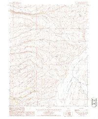
1985 Map of East of Bailey Mtn
USGS Topo · Published 1986About this map
Huntington Valley serves as the focal point for this 1985 provisional survey of the high desert terrain in Elko County. The landscape is defined by an intricate drainage system where Robinson Creek and its branches, including North Fork Robinson Creek and South Fork Robinson Creek, descend toward the valley floor. The map captures a moment in the mid-1980s when land use was dominated by rangeland infrastructure, evidenced by several water sources critical for livestock and remote habitation. Named sites like Robinson Well, Rose Well, and West Jiggs Well highlight the importance of groundwater in this arid environment, while the network of unimproved roads and trails connects these scattered points across the basin of Indian Creek and Twin Creek.
Find a feature on this map
13 named features on this map. Tap any name to fly to it.
Don’t see what you’re looking for? This feature index may not catch every label — zoom into the map to look around manually.
Map Details
Editions of this 1985 East of Bailey Mtn Map
This is the sole edition of this map. No revisions or reprints were ever made.
Other maps of this area

1934 · Jiggs
USGS Topo · 1:125,000

1937 · Jiggs
USGS Topo · 1:125,000

1955 · Elko
USGS Topo · 1:250,000

1956 · Robinson Mtn
USGS Topo · 1:62,500

1958 · Elko
USGS Topo · 1:250,000

1959 · Jiggs
USGS Topo · 1:62,500

1959 · Railroad Pass
USGS Topo · 1:62,500

1959 · Sherman Mtn
USGS Topo · 1:62,500

1962 · Elko
USGS Topo · 1:250,000

1965 · Elko
USGS Topo · 1:250,000