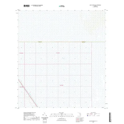
2021 Map of East of Deem City
USGS Topo · Published 2021About this map
The Everglades dominate this landscape, illustrating the vast marshland environment at the intersection of Palm Beach and Broward counties. The map reflects a nearly untouched expanse of the Floridian interior as it appeared in 2021, defined largely by wetlands and hydrological features rather than human settlement. The most significant man-made alteration to the natural drainage is the North New River Canal, which cuts diagonally across the southwestern corner. This waterway is a remnant of early twentieth-century drainage efforts designed to reclaim land from the swamp. The lack of roads, structures, or named townships emphasizes the preservation of this region as a wilderness area, where the primary markers are the sectional lines of the Public Land Survey System rather than urban development.
Find a feature on this map
7 named features on this map. Tap any name to fly to it.
Don’t see what you’re looking for? This feature index may not catch every label — zoom into the map to look around manually.
Map Details
Editions of this 2021 East of Deem City Map
This is the sole edition of this map. No revisions or reprints were ever made.
Other maps of this area

1956 · West Palm Beach
USGS Topo · 1:250,000

1957 · West Palm Beach
USGS Topo · 1:250,000

1958 · West Palm Beach
USGS Topo · 1:250,000

1963 · Andytown
USGS Topo · 1:24,000

1963 · Fort Lauderdale 2 SE
USGS Topo · 1:24,000
1963 · Cooper City NE
USGS Topo · 1:24,000

1973 · Everglades 4 NE
USGS Topo · 1:24,000
1973 · Fort Lauderdale 2 NE
USGS Topo · 1:24,000

1973 · Fort Lauderdale 2 SW
USGS Topo · 1:24,000

1974 · Everglades 1 SE
USGS Topo · 1:24,000