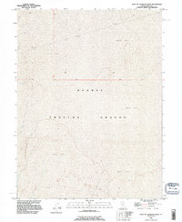
1993 Map of East of Goshute Wash
USGS Topo · Published 1996About this map
The Dugway Proving Ground dominates the landscape of this portion of Tooele County, reflecting the specialized military and geographic character of the West Desert in the early 1990s. The terrain is defined almost exclusively by the expansive Mud Flat, a feature that characterizes the Great Salt Lake Desert's southern reaches. This specific sheet captures the intersection of vast natural alkaline basins and the restricted boundaries of a major federal defense installation. Mapping revisions completed in 1995 from 1993 imagery ensure the precise delineation of the transition between the basin floor and the military reservation. The lack of traditional settlements or infrastructure highlights the isolation of this salt crust environment, where topographic variations are minimal and the land use is dedicated to large-scale military testing and research.
Find a feature on this map
4 named features on this map. Tap any name to fly to it.
Don’t see what you’re looking for? This feature index may not catch every label — zoom into the map to look around manually.
Map Details
Editions of this 1993 East of Goshute Wash Map
2 editions found
Other maps of this area

1908 · Fish Springs
USGS Topo · 1:250,000

1910 · Fish Springs
USGS Topo · 1:250,000

1953 · Tooele
USGS Topo · 1:250,000

1953 · Delta
USGS Topo · 1:250,000

1955 · Tooele
USGS Topo · 1:250,000

1958 · Delta
USGS Topo · 1:250,000

1962 · Delta
USGS Topo · 1:250,000

1967 · Fish Springs NW
USGS Topo · 1:24,000
1973 · Gold Hill 4 SE
USGS Topo · 1:24,000

1973 · Granite Peak NW
USGS Topo · 1:24,000