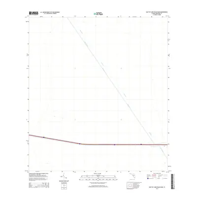
2015 Map of East of Lone Palm Head
USGS Topo · Published 2015About this map
Miami Canal and Mud Canal dominate this landscape in eastern Broward County, illustrating the massive hydrological engineering required to manage the Florida Everglades. These parallel waterways cut a straight diagonal path through the terrain, serving as primary conduits for water management and drainage. This 2015 survey reflects a region defined by its reliance on these artificial arteries, which were critical for both flood control and the reclamation of land. While the surrounding area appears largely undeveloped in this specific quadrant, the presence of these massive canals highlights the industrial scale of South Florida's water infrastructure as it stood in the early 21st century.
Find a feature on this map
2 named features on this map. Tap any name to fly to it.
Don’t see what you’re looking for? This feature index may not catch every label — zoom into the map to look around manually.
Map Details
Editions of this 2015 East of Lone Palm Head Map
This is the sole edition of this map. No revisions or reprints were ever made.
Other maps of this area

1956 · West Palm Beach
USGS Topo · 1:250,000

1957 · West Palm Beach
USGS Topo · 1:250,000

1958 · West Palm Beach
USGS Topo · 1:250,000
1973 · Everglades 4 NW
USGS Topo · 1:24,000
1973 · Everglades 4 NE
USGS Topo · 1:24,000
1973 · Everglades 4 SE
USGS Topo · 1:24,000

1973 · Everglades 4 SW
USGS Topo · 1:24,000
1973 · Everglades 3 NE
USGS Topo · 1:24,000
1974 · Everglades 1 SW
USGS Topo · 1:24,000
1974 · Everglades 2 SE
USGS Topo · 1:24,000