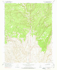
1968 Map of East of The Navajo
USGS Topo · Published 1978About this map
Fiftymile Mountain dominates this remote high-desert landscape in Kane County, Utah, where deep drainage systems have carved a complex network of canyons into the plateau. The topography is defined by the stark verticality of the Burning Hills and the winding paths of Rogers Canyon and Croton Canyon. At the time of this field check, the region remained nearly void of human development, with only a few primitive Jeep Trails providing access across the varied elevations. The seasonal water drainage patterns are evident in the named cuts of Sunday Canyon, Monday Canyon, and Navajo Canyon, which drain the eastern slopes of the mountain toward the Little Valley floor. Prominent landmarks such as West End Point and Mudholes Point mark the high edges of the plateau, offering significant reference points for navigating this portion of the East of the Navajo quadrangle.
Find a feature on this map
15 named features on this map. Tap any name to fly to it.
Don’t see what you’re looking for? This feature index may not catch every label — zoom into the map to look around manually.
Map Details
Editions of this 1968 East of The Navajo Map
2 editions found
Other maps of this area

1886 · Escalante
USGS Topo · 1:250,000

1922 · Warm Creek
USGS Topo · 1:63,360

1922 · Rees Canyon
USGS Topo · 1:63,360

1953 · Cummings Mesa
USGS Topo · 1:62,500

1953 · Gunsight Butte
USGS Topo · 1:62,500

1956 · Escalante
USGS Topo · 1:250,000

1960 · Escalante
USGS Topo · 1:250,000

1968 · East of The Navajo
USGS Topo · 1:24,000
1968 · Collet Top
USGS Topo · 1:24,000
1968 · Big Hollow Wash
USGS Topo · 1:24,000