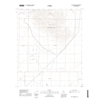
2018 Map of East of Victory Pass
USGS Topo · Published 2018About this map
Joshua Tree National Park occupies the central portion of this desert landscape, where the jagged heights of the Coxcomb Mountains rise sharply above the Chuckwalla Valley. This 2018 survey documents a critical intersection of infrastructure and wilderness, most notably where the Colorado River Aqueduct passes through the mountains via the Coxcomb Tunnel. To the south, a sparse network of roads with evocative names like Moonbeam Rd, Sidewinder Rd, and Big Sioux Trl suggests a remote desert residential or recreational footprint near the Desert Center Airport. The terrain is further defined by natural drainage systems like Pinto Wash, which cuts across the valley floor, illustrating the stark environmental contrast between the protected parklands and the developed transport corridors of Riverside County.
Find a feature on this map
24 named features on this map. Tap any name to fly to it.
Don’t see what you’re looking for? This feature index may not catch every label — zoom into the map to look around manually.
Map Details
Editions of this 2018 East of Victory Pass Map
This is the sole edition of this map. No revisions or reprints were ever made.
Other maps of this area

1943 · Coxcomb Mountains
USGS Topo · 1:62,500

1944 · Chuckwalla Mountains
USGS Topo · 1:62,500

1944 · Coxcomb Mountains
USGS Topo · 1:62,500

1952 · Sidewinder Well
USGS Topo · 1:62,500

1952 · Palen Mountains
USGS Topo · 1:62,500

1954 · Salton Sea
USGS Topo · 1:250,000

1955 · Salton Sea
USGS Topo · 1:250,000

1959 · Salton Sea
USGS Topo · 1:250,000

1963 · Salton Sea
USGS Topo · 1:250,000

1963 · Chuckwalla Mountains
USGS Topo · 1:62,500