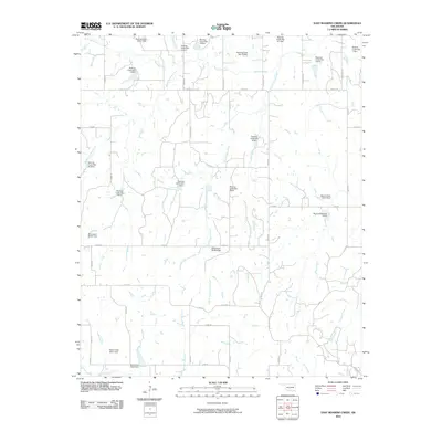
2010 Map of East Roaring Creek
USGS Topo · Published 2010About this map
Chitwood and its surrounding water management infrastructure define this landscape in Grady County. The area is heavily defined by a complex network of flood control measures along the Roaring Creek drainage system, including numerous structures such as Roaring Creek Site 11 Dam and Roaring Creek Site 101 Dam. The topography is shaped by the confluence of several waterways, with Middle Roaring Creek and East Roaring Creek feeding into the main branch, while Sandy Creek and Coon Creek drain the southeastern portions of the quadrangle.
Find a feature on this map
50 named features on this map. Tap any name to fly to it.
Don’t see what you’re looking for? This feature index may not catch every label — zoom into the map to look around manually.
Map Details
Editions of this 2010 East Roaring Creek Map
This is the sole edition of this map. No revisions or reprints were ever made.
Other maps of this area

1902 · Rush Springs
USGS Topo · 1:125,000

1949 · Rush Springs
USGS Topo · 1:62,500

1950 · Rush Springs
USGS Topo · 1:62,500

1950 · Marlow
USGS Topo · 1:62,500

1951 · Marlow
USGS Topo · 1:62,500

1957 · Ardmore
USGS Topo · 1:250,000

1963 · Ardmore
USGS Topo · 1:250,000

1966 · Lindsay SW
USGS Topo · 1:24,000
1966 · Bradley
USGS Topo · 1:24,000
1974 · Cox City
USGS Topo · 1:24,000