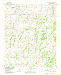
1981 Map of East Roaring Creek
USGS Topo · Published 1982About this map
Chitwood serves as a central point in this part of Grady County, where industrial development and rural community life intersect during the early 1980s. The landscape is defined by the extensive drainage systems of Roaring Creek, including its Middle and East branches, which carve through the Oklahoma terrain. Evidence of the local energy economy is prominent throughout the quadrangle, with numerous Oil Wells and a significant Refinery located near the northern settlements.
Find a feature on this map
18 named features on this map. Tap any name to fly to it.
Don’t see what you’re looking for? This feature index may not catch every label — zoom into the map to look around manually.
Map Details
Editions of this 1981 East Roaring Creek Map
This is the sole edition of this map. No revisions or reprints were ever made.
Other maps of this area

1902 · Rush Springs
USGS Topo · 1:125,000

1949 · Rush Springs
USGS Topo · 1:62,500

1950 · Rush Springs
USGS Topo · 1:62,500

1950 · Marlow
USGS Topo · 1:62,500

1951 · Marlow
USGS Topo · 1:62,500

1957 · Ardmore
USGS Topo · 1:250,000

1963 · Ardmore
USGS Topo · 1:250,000

1966 · Lindsay SW
USGS Topo · 1:24,000
1966 · Bradley
USGS Topo · 1:24,000
1974 · Cox City
USGS Topo · 1:24,000