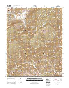
2013 Map of East Stone Gap
USGS Topo · Published 2013About this map
East Stone Gap serves as the primary focal point in this portion of Wise County, where the S Fork Powell River winds through a landscape defined by narrow hollows and high ridges. The settlement pattern reflects the traditional Appalachian geography, with community hubs like Mintons Store and Duncan Mill established along river crossings and valley floors. To the east, the rugged elevation of Little Mountain and the Big Cherry Reservoir dominate the terrain, creating a natural divide between the more densely settled Powell Valley and the remote reaches of the Jefferson National Forest. Genealogists and local researchers can trace old family locations such as Cox Place or the clusters of homes at Three Forks and Stanleytown, while various named gaps like Maple Gap mark the historical transit points through the ridges. The complex drainage network, including Cove Cr and Dry Cr, illustrates how water shaped the early roads and property lines of these mountain communities.
Find a feature on this map
101 named features on this map. Tap any name to fly to it.
Don’t see what you’re looking for? This feature index may not catch every label — zoom into the map to look around manually.
Map Details
Editions of this 2013 East Stone Gap Map
This is the sole edition of this map. No revisions or reprints were ever made.
Other maps of this area

1894 · Estillville
USGS Topo · 1:125,000

1920 · Wise
USGS Topo · 1:48,000

1921 · Big Stone Gap
USGS Topo · 1:48,000

1921 · Wise
USGS Topo · 1:62,500

1922 · Big Stone Gap
USGS Topo · 1:62,500

1929 · Big Stone Gap
USGS Topo · 1:62,500
1935 · Wise
USGS Topo · 1:24,000

1935 · Moggasin
USGS Topo · 1:48,000
1935 · Norton
USGS Topo · 1:24,000
1935 · Appalachia
USGS Topo · 1:24,000