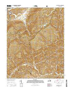
2016 Map of East Stone Gap
USGS Topo · Published 2016About this map
Powell Valley and the surrounding ridgelines define the landscape in this portion of Wise and Scott Counties, where small communities like Stanleytown and Verdi are tucked between the folds of Hunter Valley and Chestnut Ridge. The map shows a high concentration of small family and community burial grounds, such as East Stone Gap Cem, Cracker Neck Cem, and the George Starnes Cem, which serve as vital markers for local genealogical research.
Find a feature on this map
119 named features on this map. Tap any name to fly to it.
Don’t see what you’re looking for? This feature index may not catch every label — zoom into the map to look around manually.
Map Details
Editions of this 2016 East Stone Gap Map
This is the sole edition of this map. No revisions or reprints were ever made.
Other maps of this area

1894 · Estillville
USGS Topo · 1:125,000

1920 · Wise
USGS Topo · 1:48,000

1921 · Big Stone Gap
USGS Topo · 1:48,000

1921 · Wise
USGS Topo · 1:62,500

1922 · Big Stone Gap
USGS Topo · 1:62,500

1929 · Big Stone Gap
USGS Topo · 1:62,500
1935 · Wise
USGS Topo · 1:24,000

1935 · Moggasin
USGS Topo · 1:48,000
1935 · Norton
USGS Topo · 1:24,000
1935 · Appalachia
USGS Topo · 1:24,000