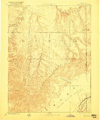
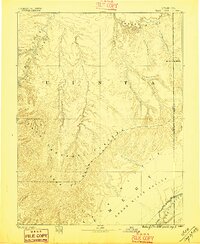
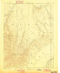
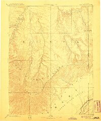
1885 Map of East Tavaputs
USGS Topo · Published 1917About this map
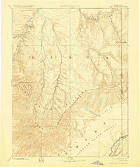
The Green River carves through the western edge of this territory, defining the deep winding corridor of Desolation Canyon. This 1885 reconnaissance survey captures a remote expanse of the Uinta region along the Utah Colorado Boundary Line during a period of primary geographical exploration. The landscape is dominated by massive geological features, including the East Tavaputs Plateau and the layered escarpments of the Roan or Brown Cliffs and Book Cliffs. In the southeast, the Grand River Valley provides a corridor for the Denver and Rio Grande Western Railroad, showing the early integration of this isolated terrain into the national rail network. Named drainages like Evacuation Creek, Asphalt Creek, and Bitter Water Creek hint at the mineral and saline character of the arid basins located between the White River and the high plateaus.
Find a feature on this map
20 named features on this map. Tap any name to fly to it.
Don’t see what you’re looking for? This feature index may not catch every label — zoom into the map to look around manually.
Map Details
Editions of this 1885 East Tavaputs Map
6 editions found
Other maps of this area

1885 · San Rafael
USGS Topo · 1:250,000

1885 · East Tavaputs
USGS Topo · 1:250,000

1885 · La Sal
USGS Topo · 1:250,000

1885 · Ashley
USGS Topo · 1:250,000

1885 · Uinta
USGS Topo · 1:250,000

1886 · Price River
USGS Topo · 1:250,000

1896 · Price River
USGS Topo · 1:250,000

1907 · Rangely
USGS Topo · 1:125,000

1907 · Jensen
USGS Topo · 1:125,000

1910 · Jensen
USGS Topo · 1:125,000