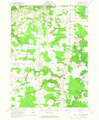
1959 Map of East Trumbull
USGS Topo · Published 1966About this map
Trumbull and the surrounding townships in Ashtabula County showcase a landscape defined by the winding course of the Grand River and its numerous tributaries. Surveyed in the late 1950s, the area is a network of rural settlements like Footville and Cork, connected by long straight roads such as Windsor-Mechanicsville Road and Footville-Richmond Road. The map reveals a high concentration of local heritage sites, including the South River Road Cemetery and several community houses of worship like South Harpersfield Ch.
Find a feature on this map
53 named features on this map. Tap any name to fly to it.
Don’t see what you’re looking for? This feature index may not catch every label — zoom into the map to look around manually.
Map Details
Editions of this 1959 East Trumbull Map
3 editions found

Other maps of this area

1904 · Chardon
USGS Topo · 1:62,500

1905 · Ashtabula
USGS Topo · 1:62,500

1905 · Perry
USGS Topo · 1:62,500

1905 · Jefferson
USGS Topo · 1:62,500

1906 · Chardon
USGS Topo · 1:62,500

1907 · Jefferson
USGS Topo · 1:62,500

1950 · Cleveland
USGS Topo · 1:250,000

1956 · Cleveland
USGS Topo · 1:250,000
1959 · East Claridon
USGS Topo · 1:24,000
1959 · Windsor
USGS Topo · 1:24,000
Featured Places
- Morgan Township, OH
- Trumbull, Trumbull Township
- Trumbull Township, OH
- Hartsgrove Township, OH
- East Trumbull, Trumbull Township