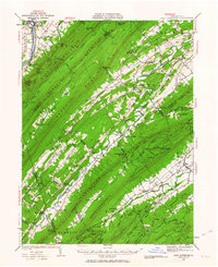
1936 Map of East Waterford
USGS Topo · Published 1963About this map
East Waterford sits at the heart of a complex ridge-and-valley system in central Pennsylvania, where numerous mountain ranges such as Tuscarora Mountain and Blacklog Mountain run in parallel corridors. This 1936 survey documents a landscape defined by small gaps and water-powered industry, evidenced by McCullochs Mills, Peru Mills, and Doyles Mills. The rural infrastructure is dense with local history, featuring numerous one-room schoolhouses like McKinley Sch and Pleasant View Sch scattered across the valleys of Tuscarora Creek and Licking Creek. Along the Juniata River in the northwest, the Pennsylvania railroad line services the towns of McVeytown and Mattawana. A notable technological landmark of the era is the Fire Tower and Airway Beacon atop Big Knob, signifying the transition into early aviation and modern forest management.
Find a feature on this map
108 named features on this map. Tap any name to fly to it.
Don’t see what you’re looking for? This feature index may not catch every label — zoom into the map to look around manually.
Map Details
Editions of this 1936 East Waterford Map
2 editions found

Other maps of this area

1919 · Newville
USGS Topo · 1:62,500

1919 · Mattawana
USGS Topo · 1:62,500

1919 · Menno
USGS Topo · 1:62,500

1922 · Mt Union
USGS Topo · 1:48,000

1923 · Shippensburg
USGS Topo · 1:62,500

1924 · Mt. Union
USGS Topo · 1:62,500

1924 · Lewistown
USGS Topo · 1:62,500

1925 · Mifflintown
USGS Topo · 1:48,000

1927 · Lewisburg
USGS Topo · 1:62,500

1930 · Loysville
USGS Topo · 1:62,500