
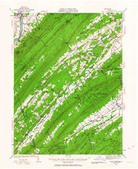
1936 Map of East Waterford
USGS Topo · Published 1936About this map
Tuscarora Mountain and Shade Mountain define the rhythmic, linear geography of this central Pennsylvania landscape, where narrow valleys dictate the flow of commerce and settlement. The 1936 survey reveals a rural economy centered on small milling outposts and community landmarks such as McCulloughs Mills, Doyles Mills, and the Game Farm. These settlements are connected by the Pennsylvania State Highway and the Central Highway, which navigate the gaps between ridges like East Waterford Narrows and Spectacle Gap.
Find a feature on this map
106 named features on this map. Tap any name to fly to it.
Don’t see what you’re looking for? This feature index may not catch every label — zoom into the map to look around manually.
Map Details
Editions of this 1936 East Waterford Map
2 editions found
Other maps of this area

1919 · Newville
USGS Topo · 1:62,500

1919 · Mattawana
USGS Topo · 1:62,500

1919 · Menno
USGS Topo · 1:62,500

1922 · Mt Union
USGS Topo · 1:48,000

1923 · Shippensburg
USGS Topo · 1:62,500

1924 · Mt. Union
USGS Topo · 1:62,500

1924 · Lewistown
USGS Topo · 1:62,500

1925 · Mifflintown
USGS Topo · 1:48,000

1927 · Lewisburg
USGS Topo · 1:62,500

1930 · Loysville
USGS Topo · 1:62,500